
Introduction to DJI Thermal Technology
Understanding Thermal Imaging
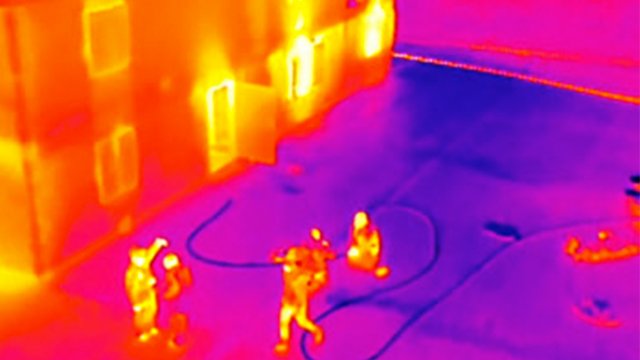
Thermal imaging is a fascinating technology that allows us to see beyond the visible spectrum. Imagine being able to detect heat signatures from objects, people, or even animals, regardless of the lighting conditions. This is precisely what thermal imaging does. It works by capturing the infrared radiation emitted by all objects. Every item has a unique thermal signature based on its temperature, making thermal cameras instrumental in various fields, from emergency response to wildlife conservation. For instance, when you’re out on a chilly night and your camera picks up the warmth from a campfire or the heat radiating from your hand, that’s thermal imaging at work. When you look through a DJI thermal camera, you’ll see a palette of colors representing different temperatures. Warmer areas could appear in bright yellows or reds, while cooler regions might show in blue or purple, creating a vivid representation of thermal information. But how does this all come together in practice? Think of search and rescue missions, where every second counts. By utilizing thermal technology, rescuers can quickly locate individuals in challenging environments like dense forests or dark buildings, identifying warm bodies that would otherwise be invisible to the naked eye.
Benefits of Thermal Technology
The advantages of thermal technology extend far beyond search and rescue. Its applications are numerous and diverse, making it a game-changer in various fields. Here’s a quick overview of the benefits:
- Enhanced Visibility: Unlike standard photography, thermal cameras operate effectively in total darkness, giving you the ability to see what lies ahead, whether it’s a search operation or inspecting a structure.
- Detection of Heat Loss: In industrial settings and building inspections, thermal cameras can detect areas where heat escapes, enabling better energy management and contributing to cost savings.
- Non-Invasive Monitoring: Thermal imaging allows the observation of wildlife or vegetation without disturbing their natural habitat, vital for environmental studies.
- Early Problem Identification: In industries like manufacturing, early detection of overheating components can prevent costly delays and accidents.
- Versatility Across Sectors: From medical applications, where thermal imaging can show inflammation or increased blood flow, to agriculture, where crop health is assessed based on temperature differentials, this technology has a broad range of uses.
Real-World Examples
Consider a situation where a farmer is concerned about the health of his crops. Utilizing a DJI thermal camera, he can easily identify sections of his field that are suffering from water stress based on the thermal signatures. Hues indicating higher temperatures might point to areas that are drying out, allowing him to optimize irrigation without wasting water. In another scenario, firefighters responding to a blaze can use thermal technology to check for hotspots within a building, seeing through smoke and darkness. This insight not only enhances their speed and efficiency but also helps ensure the safety of their team and the individuals they’re trying to rescue.
Advancements in Thermal Technology
Technology is constantly evolving, and DJI is at the forefront of these advancements. Their thermal cameras integrate high-quality sensors that provide enhanced detail and clarity, even in the most challenging conditions:
- High-Resolution Sensors: Capturing detailed images helps in more accurate assessments, whether for industrial inspections or wildlife monitoring.
- Real-Time Processing: Quick image processing allows users to instantly analyze thermal data, speeding up critical decision-making processes.
- Compact and User-Friendly Design: DJI cameras are designed to be user-friendly, making thermal imaging accessible even for those who don’t have prior experience with this technology.
Summary
In essence, DJI thermal technology revolutionizes how we interact with our environment. It equips professionals with powerful tools that enhance safety, improve efficiency, and facilitate groundbreaking research. Embracing this technology opens doors not only in traditional industries but also in innovative applications that can lead to vast improvements in our quality of life. Whether you’re in agriculture, emergency services, or environmental science, understanding and leveraging thermal imaging can profoundly enhance your operations. As we explore further, you’ll discover how DJI thermal cameras specifically cater to a variety of needs, equipping you with the tools needed to harness this transformative technology effectively.
DJI Thermal Cameras
Overview of DJI’s Thermal Camera Models
As we dive deeper into the world of thermal technology, DJI stands out as a prominent player, offering a range of thermal cameras designed to meet various needs. Whether you’re a search and rescue operator, an agricultural specialist, or an industrial inspector, there’s likely a DJI model tailored for you. 1. DJI Zenmuse XT Series The Zenmuse XT series integrates seamlessly with DJI’s drones, primarily targeted at professionals in public safety and industrial inspections. Featuring advanced thermal imaging capabilities, these cameras are equipped with high-resolution sensors that capture clear thermal representations of targets. 2. DJI Mavic 2 Enterprise Dual The Mavic 2 Enterprise Dual is a compact powerhouse, combining both visual and thermal imaging capabilities. This camera is designed for first responders and those in public safety roles, providing easy access to thermal data without the bulk of professional-grade equipment. 3. DJI Matrice 300 RTK with H20T This innovative model is a game-changer for industrial applications. The Matrice 300 RTK can be equipped with the H20T camera, which includes a thermal sensor along with a visual camera. This flexibility means you can gather all your necessary data in a single flight, whether in complex infrastructures or expansive agricultural fields. 4. DJI Inspire 2 with Zenmuse XT For filmmakers and environmentalists, the Inspire 2 with Zenmuse XT offers the ability to shoot cinematic visuals alongside thermal images. It’s perfect for creating compelling stories while collecting critical thermal data in real time. These models are just a glimpse into DJI’s expansive lineup of thermal cameras, each designed with specific applications in mind, which ensures that professionals can select precisely what they need.
Key Features and Specifications
Now, let’s highlight some key features and specifications across DJI’s thermal camera offerings that set them apart from the competition.
1. High-Quality Thermal Sensors
DJI’s thermal cameras are equipped with advanced thermal sensors that provide varied pixel resolutions, typically from 336×256 to 640×512. Higher resolutions offer greater detail, allowing users to detect subtle temperature differences, which is crucial for applications like wildlife monitoring or industrial inspections.
2. Dual Vision Systems
Models like the Mavic 2 Enterprise Dual include both visual and thermal cameras. This dual-vision capability allows operators to switch between thermal and optical imaging, enhancing situational awareness while also gathering comprehensive data.
3. Easy Integration with DJI Ecosystem
DJI thermal cameras work flawlessly with their drones, utilizing DJI’s systems for optimal performance. This integration allows users to benefit from long-range transmission, stability, and advanced flight features, making mission planning and execution straightforward.
4. Real-Time Data Analysis
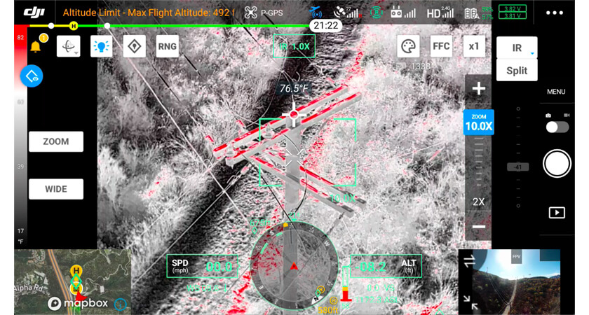
- User-Friendly Interface: DJI’s applications, such as the DJI Pilot, provide users easy access to thermal and visual data. You can view thermal readings in real time, annotate findings, and generate reports right from your mobile device.
- Thermal Palette Options: Users can choose different color palettes (like white hot or black hot) for the thermal imagery, enabling better interpretations of the data under various conditions.
5. Flight Time and Range
Typically, drones equipped with DJI thermal cameras boast impressive flight times—often around 30 to 40 minutes—depending on the model and payload. This allows extended operational periods for thorough inspections or surveillance.
6. Enhanced Image Processing Features
Features like “Spot Metering” allow you to focus on specific heat sources, providing precise temperature readings in real-time.
7. Robust Build and Weather Protection
DJI models like the Matrice series come with weather-resistant capabilities, enabling operations in various weather conditions. This durability is vital for first responders who may need to operate in challenging environments.
Summary
With such impressive features and an array of models to choose from, DJI thermal cameras are adeptly designed to enhance data collection and operational efficiency across multiple sectors. Whether in search and rescue missions, agricultural monitoring, or industrial inspections, having access to reliable and high-performing thermal technology can transform how you work. In our subsequent sections, we’ll explore the diverse applications of DJI thermal technology in detail, demonstrating how you can leverage these tools for environmental monitoring and industrial inspections. Embracing this technology not only empowers you but also underscores your commitment to innovation in your field!

Applications of DJI Thermal Technology
Search and Rescue Operations
When it comes to saving lives, time is of the essence. DJI thermal technology has emerged as a critical tool in search and rescue operations, transforming how first responders locate individuals in distress. The ability to see thermal signatures in complete darkness or adverse weather conditions empowers rescue teams to act swiftly and effectively. Imagine a scenario where a hiker goes missing in a dense forest at night. Traditional search methods might take hours, if not days, to locate the individual. However, thermal cameras can radically reduce this time frame. Here’s how:
- Thermal Imaging for Visibility: Using the DJI Mavic 2 Enterprise Dual, search teams can fly over the area and see the heat emitted from a person, even through thick foliage or darkness. The contrast in temperature makes it easy to identify a missing person.
- Enhanced Situational Awareness: With dual-vision capabilities, operators can switch between thermal and visual feeds, allowing them to confirm visuals and assess the terrain better.
- Rapid Deployment: Drones equipped with thermal cameras are lightweight and portable, enabling rapid deployment in emergencies. First responders can quickly launch a DJI drone and start searching within minutes rather than hours.
- Collaboration and Data Sharing: Rescuers can share feeds in real-time to coordinate efforts effectively. This collaborative approach is invaluable in larger operations involving multiple agencies and personnel.
For example, a rescue mission successfully locating an injured hiker relies heavily on real-time thermal imaging information. The ability to pinpoint warmth from a victim’s body can cut down search times significantly, enhancing efficiency and increasing the likelihood of a successful recovery.
Agriculture and Crop Monitoring
While search and rescue operations highlight the urgency and life-saving capabilities of DJI thermal technology, agriculture showcases its role in sustainable practices and resource management. Farmers are increasingly turning to drones equipped with thermal cameras to enhance productivity and monitor crop health. Consider a farmer observing his fields from the air. Instead of walking through rows of crops, he can deploy a DJI drone to gather vital information quickly. Here are key benefits of using thermal imaging in agriculture:
- Irrigation Management: Thermal cameras help farmers monitor the temperature of different areas across their fields, identifying spots that are over or under-watered. Plants exhibiting stress due to lack of water often emit higher temperatures. By precisely targeting these hot spots, farmers can optimize irrigation and conserve water.
- Disease and Pest Detection: Early detection is crucial for crop health. Thermal imaging can highlight areas with abnormal temperatures, signaling potential disease outbreaks or infestations. This proactive approach allows farmers to apply treatments where needed, significantly reducing reliance on pesticides and promoting sustainable farming practices.
- Yield Estimation: By assessing plant health through thermal imaging, farmers can better estimate crop yields. A deeper understanding enables more informed decisions regarding harvest times and crop rotations.
- Targeted Fertilization: Utilize thermal technology to evaluate the nutritional status of different sections of a field. This insight allows farmers to apply fertilizers only where necessary, minimizing environmental impact and costs.
Example in Practice
A practical example could be a corn farmer who utilizes a DJI Matrice 300 RTK equipped with a thermal camera during the growing season. By inspecting his field from above, he notices patches of plants showing elevated thermal signatures, indicating water stress. After confirming the results, he can implement targeted irrigation strategies, ensuring optimal growth conditions.
Benefits Beyond Immediate Needs
The applications of DJI thermal technology represent a holistic approach to agriculture that can contribute to long-term sustainability. By promoting efficient resource management, farmers achieve higher yields while also protecting the environment.
Summary
Whether in the heart of a rescue mission or the expansive fields of agriculture, the versatility of DJI thermal technology is clear. It acts as a bridge between traditional methods and innovative solutions, improving effectiveness and efficiency in critical areas. As we move forward, we will explore how DJI thermal technology continues to play a significant role in environmental monitoring and industrial inspections. This technology is not merely a tool; it paves the way for advances in how we approach challenges in various sectors, from wildlife conservation to infrastructure safety. Embracing these innovations is essential for preparing to tackle future demands while promoting a sustainable future.
Using DJI Thermal Technology for Environmental Monitoring
Monitoring Wildlife Populations
In recent years, the conservation community has faced significant challenges, from habitat loss to climate change. Using DJI thermal technology, researchers and wildlife biologists are now equipped with powerful tools to monitor wildlife populations more effectively than ever before. The ability to capture thermal imagery provides insights that were previously labor-intensive or nearly impossible to obtain. Imagine a serene night in a protected wildlife reserve. Instead of invasive tracking methods or distressing the animals, conservationists can deploy drones equipped with thermal cameras to observe nocturnal species like deer, owls, or even elusive predators like foxes. The benefits of utilizing thermal imaging in wildlife monitoring include:
- Minimally Invasive Methods: Traditional wildlife surveys can be stressful for animals, even leading to behavioral changes. Drones equipped with thermal cameras allow observers to monitor populations discreetly from a distance, minimizing disturbances.
- Increased Detection Rates: Thermal cameras excel in low-light conditions, making it easier to detect animals that are otherwise hidden. Nocturnal creatures, which are often overlooked during the day, can be surveyed, providing valuable data on their populations and movements.
- Habitat and Behavioral Assessments: Thermal imaging can help identify habitats favored by particular species, adding context to their behavioral patterns. For instance, a biologist may observe thermal signatures indicating nesting areas or critical foraging grounds.
- Real-Time Analysis: Unlike traditional methods requiring sample collection and laboratory analysis, thermal drones can provide immediate data. This allows ecologists to react quickly and apply conservation strategies effectively.
For example, consider researchers studying a population of endangered sea turtles. Using a DJI Mavic 2 Enterprise Dual, they can monitor nesting sites along coastlines. By assessing thermal differences, researchers can identify nesting success rates and the impact of environmental changes, playing a vital role in conservation efforts.
Assessing Environmental Impact
The capabilities of DJI thermal technology extend beyond wildlife monitoring and touch upon broader environmental assessments. Understanding how ecosystems change and respond to human activity requires robust data collection—something thermal imaging can provide efficiently. Here’s how thermal technology aids in environmental impact assessments:
- Heat Analysis in Urban Areas: Urban heat islands are significant concerns, as cities often experience higher temperatures than surrounding areas. Thermal drones can map temperature discrepancies across urban landscapes, helping city planners understand how infrastructure affects local climates.
- Identifying Habitat Degradation: Thermal imaging can play a crucial role in assessing changes in ecosystems. By comparing thermal data over time, researchers can identify areas of habitat loss, such as wetlands or forests, that may be disappearing due to development or climate change.
- Monitoring Agricultural Practices: As previously discussed, agriculture plays a pivotal role in our environment. Thermal technology allows authorities to monitor agricultural practices, ensuring they align with sustainable practices. For instance, if excessive water use or fertilizer runoff is detected, targeted actions can be implemented.
- Assessing Wildlife Corridors: Understanding how animals interact with their environment helps in preserving biodiversity. By utilizing thermal cameras to track movement patterns across ecologically sensitive areas, conservationists can identify critical wildlife corridors and make informed decisions about land use and protection efforts.
Practical Applications in Environmental Studies
Consider environmental scientists working to assess the impact of logging in a forest. Utilizing DJI thermal technology, they can take aerial surveys before and after logging activities to evaluate temperature changes, which can signal alterations in the local ecosystem’s health. By comparing thermal data with ecological models, researchers can contextualize their findings and advocate for sustainable logging practices, promoting balance between resource extraction and conservation.
Conclusion
The application of DJI thermal technology in environmental monitoring is undeniably transformative. From monitoring wildlife populations to assessing environmental impacts, thermal imaging provides researchers with a wealth of data that is timely, detailed, and minimally intrusive. As we aim to protect our planet and its diverse ecosystems, embracing innovative technologies like DJI thermal cameras will undoubtedly play a vital role in shaping sustainable futures. With these tools at our disposal, we can deepen our understanding of the natural world and make informed decisions for generations to come. In the next sections, we will delve into how DJI thermal technology integrates into industrial inspections, providing even more context for its extensive utility across diverse fields. So, stay tuned as we uncover how this technology can promote safety and efficiency in various industries!

Integrating DJI Thermal Technology in Industrial Inspections
Inspecting Power Lines and Pipelines
In the complex world of industrial inspections, the integration of DJI thermal technology has proven to be a game changer—especially in regimes like inspecting power lines and pipelines. The risks involved in maintaining these critical infrastructures demand regular checks to ensure both efficiency and safety. This is where thermal imaging comes in, providing a modern solution to age-old challenges. The Importance of Regular Inspections Power lines and pipelines are subject to wear and tear, weather effects, and environmental factors that can lead to significant issues, including outages or leaks. Historically, inspecting these infrastructures meant workers had to navigate difficult terrains or high altitudes, often putting themselves in harm’s way. Here’s how DJI thermal technology enhances this process:
- Visualizing Heat Loss: Using drones equipped with thermal cameras, utility companies can easily spot overheating connections in power lines. Areas emitting excessive heat can indicate faulty equipment or overloads that could lead to failures, allowing for proactive maintenance.
- Detecting Leaks: For pipelines, leaks can be detrimental, leading to hazardous spills or loss of resources. Thermal imaging can detect temperature differences along a pipeline, identifying anomalies that typically signal leaks. This is particularly effective at night or in challenging weather conditions when visual inspections fall short.
- Speed and Efficiency: Traditional ground-based inspections can be incredibly time-consuming. With drones, technicians can cover vast areas in a fraction of the time. For instance, a utility company might use a DJI Matrice 300 RTK equipped with a Zenmuse H20T camera to inspect miles of pipeline in under an hour, capturing high-quality thermal data.
A Real-World Example
Consider a maintenance team monitoring a remote power line. Instead of the arduous task of climbing poles or walking the length, they can deploy a drone. As the drone hovers near critical transformers, thermal imagery reveals hot spots within the connections. By addressing these issues before they escalate, the team ensures a stable power supply and mitigates risks. This revolutionary approach not only keeps crews safer but also minimizes downtime, enhancing overall operational efficiency.
Enhancing Building Inspections
Building inspections are another area where DJI thermal technology shines. From energy audits to identifying structural issues, thermal imaging is invaluable in delivering precise insights with minimal disruption. Benefits of Thermal Technology in Building Inspections
- Energy Efficiency Audits: As businesses and property owners increasingly look to reduce energy costs, thermal imaging provides a clear view of energy loss in buildings. Thermal cameras can detect heat escaping through missed insulation spots, poorly sealed windows, or doors, which ideally leads to corrective actions that enhance energy efficiency and sustainability.
- Identifying Plumbing Issues: Leaky pipes or water damage can be costly and disruptive. With thermal imaging, inspectors can locate moisture behind walls or beneath floors without invasive procedures, allowing for targeted repairs that save time and money.
- Assessing Electrical Systems: Just like with power lines, buildings can face potential electrical hazards. Thermal cameras enable inspectors to monitor electrical panels and connections for overheating, ensuring that issues are addressed proactively before they pose fire risks.
- Detecting Pest Infestations: Another surprising application of thermal cameras is identifying areas impacted by pest infestations. Termites and other pests often create thermal anomalies within wooden structures, which thermal imaging helps reveal. Early detection of these issues allows for prompt remediation and prevents significant structural damage.
Practical Applications: A Case Study
Imagine an aging office building requiring routine maintenance. Inspectors using DJI thermal technology can fly a drone equipped with a thermal camera around the building’s perimeter. The insights gathered reveal numerous heat losses through installation failures on the upper floors, allowing property managers to focus their resources precisely where needed for improvement. Additionally, the thermal data allows them to create comprehensive reports for stakeholders, showcasing the benefits of investing in energy efficiency upgrades without the lengthy process of conventional inspections.
Conclusion
Integrating DJI thermal technology in industrial inspections enhances safety, efficiency, and sustainability across various sectors. With groundbreaking tools at their disposal, inspectors can assess power lines, pipelines, and buildings more effectively than ever, reducing risks for both personnel and infrastructure. As the technology continues to evolve, its applications will undoubtedly expand further, supporting critical industries in maintaining their operations efficiently. In the next sections, we will explore how to unlock the full potential of DJI thermal technology, offering tips for capturing high-quality thermal images and leveraging software for data analysis and reporting. Embrace these innovations, and stay ahead of the curve in an ever-evolving landscape!
Unlocking the Full Potential of DJI Thermal Technology
Tips for Capturing High-Quality Thermal Images
Once you’ve invested in DJI thermal technology, the next step is to ensure you maximize its capabilities by capturing high-quality images. Here are some essential tips to help you make the most out of your thermal imaging sessions:
- Optimal Temperature Range:
- Thermal cameras are most effective within specific temperature ranges. Understanding the operational limits of your DJI camera is crucial. For instance, if you’re monitoring a warm structure on a cold day, the temperature contrast will yield clearer readings.
- Choose the Right Time of Day:
- Early morning or late evening provides the best conditions for thermal imaging. At these times, temperature variations in your target area are more pronounced. Early morning inspections can reveal heat loss from buildings, while evening assessments can help you identify wildlife movements.
- Adjust Thermal Palette Settings:
- DJI thermal cameras come with various palettes (like white hot and black hot). Experimenting with different palettes will allow you to choose the one that best displays the thermal data you’re seeking. Sometimes, specific palettes make it easier to see certain temperature differences, especially in complex environments.
- Maintain a Consistent Distance:
- Keeping your drone at a consistent altitude will improve the consistency of your thermal measurements. Too close, and you may not capture the whole scene; too far, and the details may become indistinct.
- Avoid Reflections:
- Reflections from glass and shiny surfaces can create false readings or obscure significant thermal differences. Try to capture images at angles where reflections will be minimized to ensure more accurate data.
- Use Image Processing Features:
- DJI software platforms often come equipped with image analysis tools. Familiarizing yourself with these features will help you process your thermal imagery post-capture, providing further insights into the data you’ve collected.
Real-World Application
Let’s say you’re tasked with conducting a building inspection at an older facility. By starting early in the morning and maintaining a consistent altitude throughout your flight, you’ll be able to capture a comprehensive overview of heat loss areas. Then, using different thermal palettes, you can compare visuals to identify specific problem zones more effectively.
Leveraging Software for Data Analysis and Reporting
Capturing excellent thermal images is just one side of the coin. The real magic happens when you analyze and present the data effectively. Here’s how to make the most of your thermal imaging software:
- Integrating Thermal and Visual Data:
- Many DJI platforms allow you to overlay thermal data on regular visual footage. This integration enhances context, making it easier to explain findings to stakeholders and clients.
- Data Organization:
- Create a systematic approach to organize your thermal images and associated data. A clear naming convention and folder structure (e.g., by date and location) will streamline both analysis and retrieval.
- Utilizing Reporting Tools:
- Many thermal imaging and drone software include reporting tools or features to generate instant reports. These reports may include annotated images, data charts, and temperature readings, which can instantly provide value to your clients.
- Highlighting Key Findings:
- When preparing reports, focus on significant heat anomalies or other key findings relevant to your inspections. Highlighting these in your presentations will direct attention to crucial insights, ensuring your audience understands the value of your work.
- Longitudinal Studies:
- If your inspections are part of a long-term monitoring effort, be sure to compare current thermal images with those from previous evaluations. Software that allows for historical data overlay can show trends and changes over time, reinforcing the value of ongoing monitoring.
Example of Software Application
Think back to that building inspection. After capturing your high-resolution thermal images, you can use DJI’s software tools to integrate those visuals into a comprehensive report. By highlighting thermal anomalies, comparing them with historical data, and including necessary visuals, you will provide stakeholders with valuable insights for decision-making. You might call it technical expertise, but it’s really about storytelling—turning data into actionable narratives that help guide your clients’ next steps.
Conclusion
Unlocking the full potential of DJI thermal technology extends beyond just capturing quality images; it encompasses a holistic approach from flight planning to post-processing analysis. With the right techniques and leveraging powerful software tools, you can elevate your inspection capabilities, whether you’re conducting building assessments, monitoring wildlife, or overseeing industrial inspections. As you continue to refine your skills in capturing and analyzing thermal data, you’ll find yourself better positioned to deliver meaningful results, enhancing safety, optimizing operations, and contributing positively to conservation and infrastructure management. Stay tuned as we wrap up the discussion surrounding DJI thermal technology and summarize its vast impact across various sectors! The possibilities are endless, and the insights gained can make a real difference in how we interact with our environment and assets.