
Introduction to Drone LiDAR Technology
Drone LiDAR technology is revolutionizing how we collect and analyze spatial data. It’s an exciting intersection of aerial vehicles and advanced sensor systems, enabling us to capture data more efficiently and accurately than ever before. But what exactly is LiDAR, and why are drones the perfect tool for this job? Let’s dive into it!
Understanding LiDAR Technology
LiDAR, or Light Detection and Ranging, is a remote sensing method that uses laser light pulses to measure distances between the sensor and the Earth’s surface. Here’s how it works:
- Laser Emission: The LiDAR system emits rapid laser pulses toward the ground.
- Reflection: These laser pulses bounce off surfaces, whether they be trees, buildings, or the ground itself.
- Recording Distances: The system measures the time it takes for each pulse to return. By calculating the speed of light, the system can determine how far away the object is.
This technology creates a highly accurate and detailed 3D model of the surveyed landscape. With LiDAR mapping, you gain insights that traditional surveying can’t match, such as:
- High-resolution terrain models
- Vegetation characteristics
- Infrastructure details
Imagine mapping a dense forest or a busy urban area with precision. You can visualize everything from the tree canopy height to the precise location of streets and buildings.
Benefits of Using Drones for LiDAR
Drones add an impressive array of benefits to LiDAR technology, making the process more efficient and cost-effective. Here are some standout advantages of using drones for LiDAR data collection:
- Accessibility: Drones can easily reach areas that are difficult or dangerous for human surveyors. Think of remote mountain peaks or dense jungles; drones can fly over them safely.
- Cost-Effectiveness: Traditionally, aerial surveys required expensive helicopter rentals or ground crews. With drones, costs shrink significantly while improving speed and efficiency.
- Speed of Data Collection: Drones can cover large areas in a fraction of the time it would take ground crews. Imagine finishing a week’s worth of work in a day!
- High Precision and Accuracy: Equipped with advanced LiDAR sensors, drones can provide centimeter-level accuracy. When it comes to surveying land for construction or resource management, this precision is invaluable.
- Reduced Human Error: Automation removes much of the possibility for human error during data collection. Drones can consistently capture data from the same altitude and angle, ensuring a uniform dataset.
- Multifunctionality: Drones equipped with different sensors can capture various types of data (e.g., RGB imagery, thermal data, and LiDAR) in a single flight. This multi-layered approach enriches your understanding and analysis.
To put it in perspective, consider a recent project where a team conducted a survey for a new housing development. Instead of sending out dozens of people with measuring tools over several weeks, a single drone completed the LiDAR mapping in just a couple of hours. The resulting data was not only faster but also more accurate, allowing the planners to make informed decisions promptly.
Table: Comparison of Traditional Surveying vs. Drone LiDAR Surveying
| Aspect | Traditional Surveying | Drone LiDAR Surveying |
|---|---|---|
| Cost | High | Lower |
| Data Collection Time | Weeks | Hours |
| Accessibility | Limited | High (remote/terrain) |
| Accuracy | Variable | Centimeter-level |
| Human Interaction Required | High | Low |
| Versatility | Low | High (multi-sensors) |
In conclusion, the integration of drones in LiDAR technology not only enhances the ease of data collection but also vastly improves the quality and quantity of information we can gather about our environment. The flow of advanced technology into everyday applications is fascinating and opens up limitless possibilities for various industries! In the next section, you’ll learn about the different types of LiDAR sensors designed specifically for drones. Stay tuned, as you’ll want to understand how to choose the right sensor for your needs!
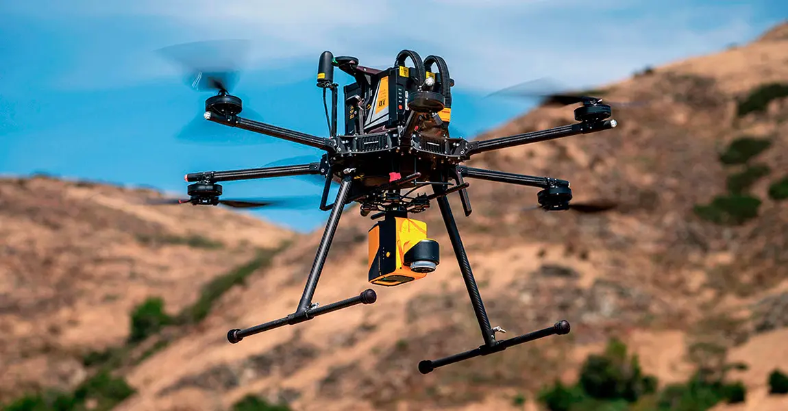
Types of LiDAR Sensors for Drones
Now that we’ve established the significance and benefits of drone LiDAR technology, let’s delve deeper into the types of LiDAR sensors commonly used in drone applications. These sensors are crucial for capturing accurate data and vary significantly in design and functionality. We can categorize them into two primary types: terrestrial LiDAR sensors and aerial LiDAR sensors.
Terrestrial LiDAR Sensors
Terrestrial LiDAR sensors are typically ground-based systems that use laser scanning to collect detailed architectural and topographical information. Although traditionally associated with stationary setups, these sensors have found a place in drone applications as well. Key Features of Terrestrial LiDAR Sensors:
- High Resolution: Terrestrial LiDAR sensors can capture highly detailed three-dimensional data.
- Short Range: They are best suited for surveying within short distances, often ranging from a few centimeters to several hundred meters.
- Static or Mobile: These sensors can be mounted on tripods or vehicles, or even integrated into a drone for specific applications.
Applications in Drone Use:
- Heritage Preservation: When my friend worked on a project to document historical sites, they used a terrestrial LiDAR sensor mounted on a drone to navigate the terrain while capturing intricate details of ancient structures.
- Construction Site Monitoring: These sensors provide precise measurements for ongoing construction projects, allowing for quality control and risk management.
Advantages:
- Detail-Oriented: Ideal for capturing intricate details of structures, such as facades of buildings or road surfaces.
- Real-Time Data: Many terrestrial sensors allow for real-time data processing, leading to quicker decision-making.
Limitations:
- Limited Range: Not suitable for large area surveys or landscapes.
- Labour-Intensive Setup: Requires careful planning and setup, which can slow down the data collection process.
Aerial LiDAR Sensors
In contrast, aerial LiDAR sensors are specifically designed for use with unmanned aircraft systems (UAS), such as drones. These sensors are lighter, compact, and optimized for aerial data acquisition over vast areas. Key Features of Aerial LiDAR Sensors:
- Long Range: Capable of capturing data from heights that can exceed several hundred meters, making them suitable for large-scale mapping projects.
- Efficiency: Aerial LiDAR sensors can collect data quickly over expansive areas, thanks to their rapid-fire laser emission capabilities.
- Multi-Spectral Capabilities: Some aerial LiDAR sensors can integrate additional sensors to collect RGB imagery, thermal data, or even multispectral data.
Applications in Drone Use:
- Topographic Mapping: Aerial LiDAR sensors excel at creating detailed elevation maps for forestry management, urban planning, and flood modeling.
- Power Line Inspection: They are frequently used in the utility industry to inspect power lines and ensure safety regulations are met. I experienced this firsthand on a project that involved inspecting power transmission lines across a forested area—from a bird’s-eye view, you could easily identify potential hazards.
Advantages:
- Scalability: Perfect for large area surveys, such as forests, mining sites, and urban landscapes.
- Speed and Efficiency: Aerial surveys can cover much more ground in less time compared to terrestrial sensors.
Limitations:
- Lower Detail Resolution: While effective for large areas, they may not capture the same level of detail for intricate structures as terrestrial sensors.
- Sensitivity to Environmental Conditions: Weather and atmospheric conditions may impact sensor performance. For example, flight on a foggy day can be less effective.
Table: Comparison of Terrestrial vs. Aerial LiDAR Sensors
| Aspect | Terrestrial LiDAR Sensors | Aerial LiDAR Sensors |
|---|---|---|
| Range | Short (up to 300m) | Long (up to 1,500m or more) |
| Detail Level | High detail | Moderate detail |
| Best Use Case | Detailed structure analysis | Large area mapping |
| Setup Time | Longer | Shorter |
| Environmental Sensitivity | Less affected | Highly affected |
To sum it all up, choosing the right type of LiDAR sensor for your drone project hinges on your specific needs: Are you looking for detail-oriented data, or are you trying to survey large areas quickly? Knowing the strengths and weaknesses of both terrestrial and aerial LiDAR sensors will help you make an informed decision for your next project. Next, let’s explore the wide variety of applications where drone LiDAR is making a significant impact—from agriculture to urban development. Buckle up for some interesting insights!

Applications of Drone LiDAR
As we explore the multifaceted world of drone LiDAR, it’s essential to highlight its broad range of applications. The potential of this technology is transforming various industries by providing precise data that allows for informed decision-making. Two prominent areas where drone LiDAR is making significant headway are agriculture and crop monitoring, as well as urban planning and infrastructure development.
Agriculture and Crop Monitoring
In the agricultural sector, effective data collection is key to increasing productivity and sustainability. Drone LiDAR plays a pivotal role in precision agriculture by creating accurate terrain models and assessing crop health. Here’s how drone LiDAR is utilized in agriculture:
- Field Mapping: By capturing detailed elevation data, farmers can understand the topography of their fields, optimizing irrigation and drainage systems. During a project for a local farming cooperative, I witnessed firsthand how a drone created a 3D model of their fields, revealing areas that required changes in drainage to prevent waterlogging.
- Crop Health Monitoring: By integrating laser sensors and multi-spectral cameras, drones can evaluate crop density and health. This allows farmers to identify stressed areas and apply inputs like fertilizers or pesticides only where necessary, reducing overall input costs.
- Yield Estimation: Utilizing LiDAR data, farmers can estimate yields more accurately than with traditional methods. This information is invaluable for planning harvest schedules and for financial forecasting.
- Soil Analysis: Mapping soil properties becomes more efficient as drones assess different soil types across vast areas. Soil texture, moisture levels, and organic matter content can all inform better planting strategies.
Benefits of Drone LiDAR in Agriculture:
- Enhanced crop yield through targeted management
- Reduced costs and resource waste
- Improved decision-making based on high-resolution data
Table: Impact of Drone LiDAR on Agriculture
| Application | Benefits |
|---|---|
| Field Mapping | Optimized irrigation, tailored drainage solutions |
| Crop Health Monitoring | Targeted treatments for stressed crops |
| Yield Estimation | Improved financial and harvest planning |
| Soil Analysis | Informed planting strategies |
In my conversations with farmers, it’s clear they value how drone technology and LiDAR can provide them insights that traditional farming methods might miss.
Urban Planning and Infrastructure Development
As urban landscapes continue to evolve, cities need precise data to ensure effective planning and development. Drone LiDAR offers an innovative approach for urban planners, architects, and civil engineers. Key applications in urban planning include:
- Topographic Surveys: Drone LiDAR generates detailed elevation models that help planners understand existing terrain and slopes. For instance, during a recent city redevelopment project, LiDAR data assisted in designing stormwater drainage systems to manage runoff effectively.
- 3D Modeling of Infrastructure: By capturing point clouds, urban planners can create highly accurate 3D models of buildings, roads, and other infrastructure. These models allow them to visualize design changes more effectively and facilitate public engagement.
- Land Use Mapping: Understanding land use patterns is crucial for strategic urban development. Drone LiDAR helps identify vacant lots, green spaces, and potential locations for new facilities or infrastructure.
- Construction Monitoring: Throughout a construction project, LiDAR can provide regular updates on progress, comparing planned designs to as-built conditions. This tracking ensures that projects stay on budget and meet regulatory requirements.
Benefits of Drone LiDAR in Urban Development:
- Improved efficiency and accuracy in data collection
- Cost-effective solutions for large-scale mapping
- Enhanced stakeholder engagement through visual data representation
Table: Advantages of Drone LiDAR for Urban Planning
| Application | Benefits |
|---|---|
| Topographic Surveys | Accurate terrain data for effective planning |
| 3D Modeling | Visualize changes and design proposals |
| Land Use Mapping | Strategic identification of development opportunities |
| Construction Monitoring | Regular updates ensure project compliance |
In my experience working with various urban planners, the speed and accuracy with which LiDAR can gather data have truly changed the game. One planner shared how they were able to reduce planning time for a new park project by over 30% thanks to the clear, comprehensive data provided by drone LiDAR. To wrap it up, the applications for drone LiDAR technology are not only impressive but also vital for modernized agriculture and urban development. As we continue to leverage this technology, the possibilities for enhanced efficiency and sustainability are boundless. As we move forward, we will delve into how to choose the right drone for your LiDAR needs, ensuring you have the right tool for your projects. Exciting times ahead!
How to Choose the Right Drone for LiDAR
After understanding the incredible applications of drone LiDAR, you might be eager to get started on your own projects. However, selecting the right drone for your LiDAR needs is crucial for achieving the best results. With a plethora of options available, it can feel overwhelming. Let’s break it down into manageable pieces, starting with the key factors to consider when making your choice.
Factors to Consider
When choosing a drone for LiDAR, several essential factors can influence your decision:
- Payload Capacity: Different LiDAR sensors have varying weights. You’ll need a drone that can carry your desired LiDAR sensor comfortably. For example, if you’re looking to integrate a high-end sensor, make sure your drone can handle that weight without compromising flight stability.
- Flight Time: The drone’s battery life will dictate how long it can remain airborne, directly affecting how much area you can survey in one go. Longer flight times mean fewer battery changes, which can disrupt your workflow. A drone offering 30 minutes or more of flight time is generally advisable.
- Range and Altitude: Consider the maximum altitude at which the drone can operate and the effective range of the LiDAR sensor. If your project involves large areas or specific topographies, you’ll want a drone capable of flying higher to cover more ground efficiently.
- Data Quality and Accuracy: Different drone models and sensors deliver varying levels of data quality. Look for drones equipped with advanced positioning systems and real-time kinematic (RTK) capabilities to ensure the highest accuracy.
- Software Compatibility: Ensure the drone can integrate with the LiDAR data processing software you plan to use. Compatibility with popular programs can streamline your workflow and enhance data analysis.
- Ease of Use: If you’re new to drone flights, consider models known for their user-friendly interfaces and features. Many drones come with automated flight planning software, which can greatly reduce the complexity of your operations.
- Regulatory Compliance: Ensure the drone meets local regulations and guidelines for operating in the airspace where you intend to fly. Familiarizing yourself with these rules could save you from fines or operational setbacks down the line.
Popular Drone Models for LiDAR Mapping
Once you’ve assessed your needs based on the factors mentioned above, it’s time to look at some popular drone models currently favored for LiDAR mapping. I’ve gathered some information on a few standout options based on their performance, features, and user feedback. 1. DJI Matrice 300 RTK
- Payload: Up to 2.7 kg (around 6 lbs)
- Flight Time: Approximately 55 minutes
- Features: RTK positioning for high accuracy, extensive compatibility with various sensors, rugged design.
- Best For: Projects requiring long flight times and high payload capacities.
2. Quantum Systems Trinity F90+
- Payload: Supports various LiDAR sensors, typically around 1.5 kg.
- Flight Time: Up to 90 minutes
- Features: Vertical takeoff and landing, fixed-wing endurance, integrated precision GNSS.
- Best For: Large area surveys with extended flights in difficult terrains.
3. senseFly eBee X
- Payload: Up to 1.5 kg, including wide-ranging LiDAR sensors.
- Flight Time: Around 90 minutes, depending on sensor attachment.
- Features: Geo-referenced data, fixed-wing design for efficiency, easy automatic flight planning.
- Best For: Comprehensive mapping projects covering vast areas—ideal for agriculture and environmental studies.
4. WingtraOne
- Payload: Up to 1.2 kg with diverse sensor options, including LiDAR.
- Flight Time: About 59 minutes.
- Features: Vertical takeoff and landing along with fixed-wing capabilities, dual GNSS for increased accuracy.
- Best For: Versatile mapping solutions in varied environments.
Comparison Table: Drone Models for LiDAR Mapping
| Model | Payload Capacity | Flight Time | Best For |
|---|---|---|---|
| DJI Matrice 300 RTK | Up to 2.7 kg | Approx. 55 mins | Long-duration surveys |
| Quantum Systems Trinity F90+ | Up to 1.5 kg | Up to 90 mins | Large area surveys |
| senseFly eBee X | Up to 1.5 kg | Around 90 mins | Vast area mapping |
| WingtraOne | Up to 1.2 kg | About 59 mins | Versatile mapping in varied environments |
Choosing the right drone for LiDAR reporting requires a careful analysis of your specific project needs. Each drone model offers unique advantages that can help streamline your data collection and analysis process. In conclusion, taking the time to evaluate your requirements will lead you to the perfect drone model for your LiDAR initiatives. In the following sections, we’ll dive into planning and executing your LiDAR mapping projects, ensuring you have the steps you need to succeed. Exciting times lie ahead!
Planning and Executing a LiDAR Mapping Project
With the right drone selected for your LiDAR mapping project, the next crucial step involves thorough planning and execution. This stage ensures everything goes smoothly from the moment you take off to when you process and analyze the data. Let’s break it down into two key components: the pre-flight checklist and the data processing and analysis techniques.
Pre-flight Checklist
Before heading out to capture your LiDAR data, having a pre-flight checklist can save you from potential setbacks. I can vividly recall a time when I neglected to prepare properly, which resulted in an unexpected delay due to forgetting a crucial piece of equipment. Keep the following checklist handy:
- Check the Weather: Ensure weather conditions are suitable for flying:
- Clear skies and low winds are ideal for accurate data collection.
- Monitor for changing weather patterns that could impact the flight.
- Inspect the Drone: Perform a thorough inspection of the drone:
- Check battery levels and ensure all batteries are charged.
- Inspect propellers, motors, and the overall drone structure for any signs of damage.
- Ensure the LiDAR sensor and any additional equipment are securely mounted.
- Software and Firmware Updates: Make sure the drone’s firmware and software are up to date:
- This ensures optimal performance and access to the latest features or fixes.
- Run a check on the LiDAR system for any firmware updates.
- Flight Plan: Prepare your flight mission:
- Use flight planning software to outline the survey area and flight path.
- Define the altitude and overlap settings based on your specific project goals. A good practice is to aim for at least 60% overlap for LiDAR data.
- Permissions and Regulations: Verify that you have all necessary permits and are compliant with local regulations:
- Familiarize yourself with any airspace restrictions in the area.
- Ensure you’re in compliance with FAA regulations or other relevant authorities.
- Communication Setup: Establish communication protocols:
- Ensure you have a reliable way to communicate with your team on the ground.
- If you’re operating in a remote area, consider having backup communication methods like two-way radios.
By going through this checklist, you’ll be well-prepared, minimizing the chances of issues during the flight and ensuring a productive data collection session.
Data Processing and Analysis Techniques
Once the data collection is complete, the next vital step is processing and analyzing that data. Effective data processing techniques are crucial not only for accuracy but also for deriving meaningful insights. Here’s an approach you can follow:
- Data Calibration:
- Calibrate the LiDAR data to remove any systematic errors caused during flight. This may involve aligning the data with known ground control points (GCPs) to enhance accuracy.
- Most modern LiDAR software can automatically correct for sensor alignment issues based on pre-set parameters.
- Point Cloud Generation:
- The raw data collected is processed into a point cloud. This collection of points represents the X, Y, and Z coordinates of the surveyed features.
- Utilize software like Autodesk ReCap or LAStools to efficiently handle point cloud creation.
- Filtering and Classification:
- Filter the point cloud to remove noise and irrelevant data points from the dataset, such as outliers and reflections.
- Classify the point cloud data into different categories (e.g., ground, buildings, vegetation) for easier analysis. Many software options provide machine learning capabilities to improve classification accuracy.
- Data Visualization:
- Visualizing your data can help in comprehending complex datasets. Import your classified point cloud into visualization tools such as QGIS or ArcGIS.
- Creating 2D or 3D visualizations can provide insight into the spatial relationships of the surveyed features.
- Creating Elevation Models:
- From the filtered and classified point cloud, generate Digital Elevation Models (DEM) or Digital Terrain Models (DTM) to understand the topography of the area.
- These models are incredibly useful in applications like land-use planning, flood modeling, and infrastructure development.
- Analysis and Reporting:
- Use the processed data to conduct analyses pertinent to your project goals. This might include calculating volumes, conducting line-of-sight analyses, or studying vegetation density.
- Compile your findings neatly for presentation to stakeholders, ensuring that insights derived from the data are easily understood and actionable.
Table: Key Steps in Data Processing and Analysis
| Step | Description |
|---|---|
| Data Calibration | Correct systematic errors using ground control points |
| Point Cloud Generation | Convert raw data into 3D point cloud |
| Filtering and Classification | Remove noise; categorize data into meaningful classes |
| Data Visualization | Use tools to create visual representations |
| Creating Elevation Models | Generate DEM/DTM for terrain analysis |
| Analysis and Reporting | Conduct analyses and compile findings for stakeholders |
As you can see, the process of planning and executing a LiDAR mapping project involves careful preparation and thorough data processing. In my experience, taking the time to ensure everything is in order not only yields high-quality data but also makes for a more pleasant, less stressful work environment. In the next section, we will examine the regulatory considerations you need to keep in mind when operating drone LiDAR systems, ensuring that you adhere to necessary guidelines. Let’s keep moving forward on this exciting aerial adventure!
Regulatory Considerations for Drone LiDAR Operations
As we delve into the world of drone LiDAR operations, it’s essential to recognize the regulatory landscape governing these activities. Understanding these regulations not only ensures compliance but also enhances the safety and effectiveness of your projects. Regulatory considerations can vary from one region to another, but let’s first focus on the regulations set forth by the FAA in the United States before moving on to international standards.
FAA Regulations in the United States
In the U.S., the Federal Aviation Administration (FAA) oversees all aspects of civil aviation, including drone operations. If you plan to conduct LiDAR surveys using drones, it’s crucial to familiarize yourself with the following regulations:
- Part 107 Certification:
- To legally operate a drone for commercial purposes, you need to obtain a Remote Pilot Certificate under FAA Part 107.
- This certification process involves passing a knowledge test covering topics like airspace classification, weather, and drone operation regulations.
- Weight Limitations:
- The FAA permits drones to weigh up to 55 pounds (including payload). If your LiDAR sensor and drone combo exceed this weight, you may need to explore special airworthiness certificates, which can be more complex to obtain.
- Visual Line of Sight (VLOS):
- Under Part 107, pilots must maintain a visual line of sight with their drone at all times. This means no flying beyond visual range without a visual observer and a waiver from the FAA.
- Flight Restrictions:
- Pay heed to areas where operations may be restricted. For example, drones can’t fly over people or moving vehicles and are prohibited in controlled airspace without proper authorization. Utilizing the FAA’s UAS Data Label tool can help in checking airspace restrictions before flights.
- Notify Authorities:
- If you plan to fly in certain areas (near airports or high-traffic zones), you must notify the relevant authorities. This includes notifying Air Traffic Control (ATC) when applicable.
- Operational Limitations:
- The FAA limits drone operations to daylight hours or civil twilight. Night operations require additional waivers and specific lighting equipment on drones.
- Accident Reporting:
- If your drone is involved in a serious accident, you must report it to the FAA within 10 days. Familiarizing yourself with the reporting procedures is essential for compliance.
Having navigated these regulations a few times, I can share that preparation is key. For instance, before embarking on a LiDAR mapping project, a colleague of mine meticulously reviewed all FAA rules, ensuring her flight plan adhered to the regulations. This proactive approach not only kept her compliant but also paved the way for smooth, successful operations.
International Regulations for LiDAR Mapping with Drones
While the FAA governs drone operations in the U.S., operating internationally implies an entirely different set of regulations, which can vary considerably by country. Here are some key considerations when working with LiDAR mapping in an international context:
- National Aviation Authorities:
- In most countries, drone operations fall under the jurisdiction of national aviation authorities (e.g., the European Union Aviation Safety Agency (EASA) in Europe). Familiarize yourself with the local regulations before your flight.
- Licensing Requirements:
- Different nations have varying licensing requirements, sometimes even mandating additional certification even if you already hold a Part 107 certificate. For example, many countries in Europe require drone pilots to complete specific training programs.
- Weight and Size Restrictions:
- Most regulations impose weight limits similar to those of the FAA, but local thresholds may vary. Always check the specific requirements for the country in which you are operating.
- Operational Limitations:
- Like the FAA, many countries impose restrictions on flying over certain areas (such as populous regions or critical infrastructure). Familiarity with the no-fly zones and operational guidelines is critical to avoid fines or suspension.
- Privacy Laws:
- Privacy laws concerning aerial photography and data collection vary significantly worldwide. It’s crucial to understand local laws governing data collection, especially when collecting sensitive information related to properties.
- Import/Export Regulations:
- If you’re bringing your drone into another country, be mindful of import regulations that may require permits or customs declarations.
Table: Comparison of FAA and International Drone Regulations
| Aspect | FAA (United States) | International Regulations |
|---|---|---|
| Certification | Remote Pilot Certificate | Varies by country; often specific training required |
| Weight Limit | Up to 55 lbs | Similar, but country-specific variations exist |
| Flight Restrictions | VLOS, no flying over people | Local regulations can vary widely |
| Operational Time | Daylight or civil twilight | Varies, often requires waivers for night operations |
| Privacy Considerations | Basic reporting requirements | Stronger privacy laws in many countries |
| Import/Export Restrictions | Regulation by U.S. Customs | Strict regulations may apply depending on the country |
In conclusion, navigating drone LiDAR operations requires a keen understanding of both local and international regulations. From FAA guidelines to the myriad of international laws, adhering to these regulations can make or break your data collection project. Being well-informed not only protects you legally but also fosters trust and safety within the communities where you’re operating. Now that you have a solid foundation regarding regulatory considerations, it’s time to explore more about integrating LiDAR data into your projects. Let’s dive into some advanced techniques next!