Introduction to Drone Flying Zones
When you decide to take to the skies with your drone, it’s essential to understand the rules that govern where you can and cannot fly. Knowing your drone flying zones isn’t just a good practice; it’s your responsibility as a pilot. So, let’s delve into the importance of being aware of these zones and the regulations that come with them.
Importance of Knowing Drone Flying Zones
Imagine you’ve just bought the latest drone model. You’re eager to capture breathtaking aerial shots of your local park, and the sky seems like the perfect canvas. But wait! Are you familiar with your flying area? Understanding drone flying zones can save you not only from potential fines but also from endangering yourself and others. Here are a few reasons why it’s crucial to know your drone flying zones:
- Safety for All: Knowledge of your flying zones ensures that you maintain a safe distance from people, buildings, and vehicles. For instance, if you accidentally fly into a crowded beach on a busy summer day, you’re posing a safety risk.
- Avoiding Legal Issues: Many regions have specific laws regarding drone flying, including no-fly zones. Ignoring these can lead to hefty fines or even confiscation of your drone. I remember a friend who got his drone seized at a sports event because he overlooked a simple rule about not flying in designated areas.
- Enjoyment of Hobby: Knowing where you can fly means you can enjoy your hobby to the fullest. You wouldn’t want to have to cut your flight short just because you’re unsure of the regulations. Being informed allows you to find the best spots and enjoy your time in the air.
In sum, understanding drone flying zones not only benefits you as a pilot but also contributes to the overall safety and enjoyment of the drone community.
Regulations and Restrictions
Once you’re aware of the importance of knowing drone flying zones, the next step involves understanding the specific regulations and restrictions that come with them. Regulations help ensure safety in the airspace and provide a framework within which all drone operators must operate. Here’s a breakdown of some key regulations you should familiarize yourself with:
- Federal Aviation Administration (FAA) Regulations: In the United States, the FAA outlines the primary regulations for drone flying. Key points include:
- Registration: If your drone weighs over 0.55 pounds, it needs to be registered with the FAA.
- Altitude Limits: You’re generally required to maintain a maximum altitude of 400 feet above ground level.
- Line of Sight: Always keep your drone within visual line of sight while flying. This means you should be able to see your drone without the aid of binoculars or a camera.
- No-Fly Zones: These zones are generally established for safety and security reasons, and you should avoid flying in or around them. Common examples include:
- Near Airports: Keeping a safe distance from airports is crucial to avoid interfering with planes. Typically, this zone extends up to five miles from an airport.
- Crowded Events: Areas such as concerts, sports events, and large gatherings often have restrictions to protect the safety and privacy of individuals.
- Government Buildings and Military Bases: These areas can have strict regulations, and flying there can lead to severe penalties.
- State and Local Laws: In addition to FAA guidelines, remember that individual states and local jurisdictions may have their own rules regarding drone use. It’s important to check for specific regulations in the area you plan to fly. For instance, some parks might prohibit drone flying altogether, while others may require permits.
- Insurance Requirements: While not a strict regulation, considering drone insurance can be a smart move. If you accidentally damage someone’s property or injure someone while flying, having insurance could save you from hefty out-of-pocket expenses.
- Endangering Wildlife: Be mindful of flying near wildlife, especially in protected areas. Disturbing animals can have serious ecological impacts, and many national parks strictly prohibit drone flying.
- Drone Flight During Adverse Weather: Weather conditions play a significant role in drone flying. Avoid operating your drone in high winds or rain, as this can lead to loss of control and potential accidents. I recall one instance where I attempted to fly my drone in windy conditions, and I barely managed to land it without crashing!
By understanding the nuanced regulations and restrictions that apply to drone flying, you’re not just becoming a more responsible pilot; you’re also sharing the skies harmoniously with other airspace users. In conclusion, the world of drone flying comes complete with its own set of joys and challenges. Knowing your drone flying zones, along with the accompanying regulations, not only enhances your flying experience but also ensures the safety of those around you. Armed with this knowledge, you can soar into the skies with confidence, knowing that you’re flying responsibly! 🌍✈️

Understanding Airspace Classifications
Now that you have a good grasp of drone flying zones and the importance of regulations, it’s time to dive deeper into understanding how airspace classifications work. Whether you’re an amateur flyer or a seasoned pilot, knowing different classes of airspace is vital for safe and lawful flying. Let’s break down these classifications and what you need to know.
Class A to Class G Airspace
Airspace is divided into several classifications, each with its own set of rules and requirements. These classifications range from Class A, which is the most restrictive, to Class G, the least restrictive. Understanding these classifications can be compared to being on a busy highway: some lanes are meant for fast-moving traffic, while others are designated for local cars or even slower vehicles. Here’s a closer look at each class and its implications for drone pilots.
- Class A Airspace:
- Characteristics: Class A airspace typically runs from 18,000 feet up to 60,000 feet above sea level. It’s mostly used by commercial airliners and requires air traffic control (ATC) clearance for entry.
- Drone Implication: Drones are not allowed in Class A airspace, unless you have specific permission from the FAA, which is rare. So, for the average drone enthusiast, flying in this class is a no-go zone.
- Class B Airspace:
- Characteristics: Class B airspace surrounds the nation’s busiest airports. It extends from the surface up to about 10,000 feet in altitude and consists of a solid blue line on airspace maps.
- Drone Implication: Flying drones here is challenging. You’ll need ATC permission, and you’ll have to follow strict operational guidelines to ensure safety.
- Class C Airspace:
- Characteristics: Class C airspace surrounds airports with a moderate level of traffic and is usually from the surface to 4,000 feet above ground level. It is represented by a solid magenta line on maps.
- Drone Implication: Similar to Class B airspace, you need permission to fly in this zone. However, the requirements may be slightly less stringent compared to Class B, making it a bit more accessible.
- Class D Airspace:
- Characteristics: Class D airspace surrounds smaller airports (typically with a control tower) and extends from the surface up to 2,500 feet above ground level. It’s marked with a dashed blue line.
- Drone Implication: You are required to contact the tower for permission before flying. Understanding local communication procedures is crucial here.
- Class E Airspace:
- Characteristics: This class encompasses all airspace that is not Class A, B, C, or D and primarily exists to facilitate transitions between classes. It starts from either the surface or above 1,200 feet, depending on the location.
- Drone Implication: Class E airspace is generally easier to navigate, but you should still be aware of weather reversals and other air traffic operating nearby.
- Class G Airspace:
- Characteristics: Known as uncontrolled airspace, Class G airspace typically extends from the surface up to 1,200 feet. This area is often found away from busy airports and in rural regions.
- Drone Implication: This is the most favorable zone for drone flying. Pilots can operate their drones here with fewer restrictions, but it’s still essential to be aware of other aircraft.
While learning these classes might feel a bit like cramming for a test, remember: this knowledge will keep you safe and legal when flying your drone.
Restricted and Special-Use Airspace
Beyond the general classes of airspace, there are also specific classifications known as restricted and special-use airspace that every drone pilot should be aware of.
- Restricted Areas:
- Characteristics: Restricted airspace is designated for security or other reasons where unauthorized aircraft cannot operate without permission. This can include military installations, large gatherings, or significant government buildings.
- Drone Implication: Flying in a restricted area without permission is illegal and can lead to serious consequences. Always check for these zones on local charts before you take off.
- Prohibited Areas:
- Characteristics: No-fly zones fall under this category, where operations are strictly banned regardless of the purpose. Common examples include areas around the White House or other vital national security sites.
- Drone Implication: Staying away from these areas is non-negotiable. If you’re caught flying in these zones, it’s not just a fine; you can face criminal charges.
- Warning Areas:
- Characteristics: These areas are established to warn non-participating pilots of potential hazards, usually due to military operations. They extend from 3 nautical miles outward from the coast or national boundaries.
- Drone Implication: While warning areas are not prohibited, it is wise to avoid them due to the risk of active military aircraft and operations.
- Military Operations Areas (MOAs):
- Characteristics: MOAs are designed to separate military training activities from other air traffic. While they are not restricted, they may have significant military traffic.
- Drone Implication: Stay informed about military schedules and avoid flying during their active hours if possible.
- Temporary Flight Restrictions (TFRs):
- Characteristics: TFRs are temporary boundaries around areas needing special protection, such as during natural disasters or major events.
- Drone Implication: Always check for TFRs before flying and respect these temporary boundaries to ensure everyone’s safety.
Understanding these classifications helps you make informed flying decisions. When I first started flying, I made it a point to study these classifications in detail. It not only improved my skills but also boosted my confidence while navigating through the skies. I can’t stress enough how valuable this knowledge is! In summary, understanding airspace classifications is crucial for operating a drone responsibly. By adhering to these guidelines, you’ll not only keep yourself safe but also contribute to the safety of others flying in the same skies. Stay informed, communicate effectively, and enjoy your flights! 🛩️✨

Fly Zone Mapping Tools
Now that you’ve got a solid understanding of airspace classifications and the importance of knowing where you can fly, it’s time to talk about how to access this information easily. Enter fly zone mapping tools! These tools serve as your best friends when planning your drone flights, ensuring you stay within legal boundaries while enjoying your hobby. Let’s explore some popular apps for checking drone zones and the features they offer.
Popular Apps for Checking Drone Zones
There are numerous drone mapping applications available that can help you check fly zones while offering a user-friendly experience. Here are some of the most popular options, each with its unique advantages:
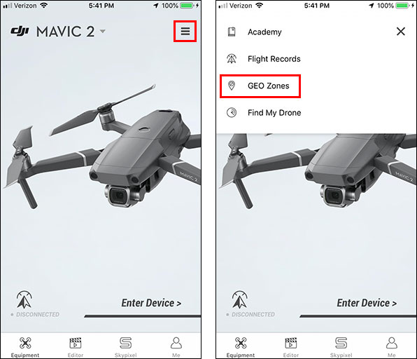
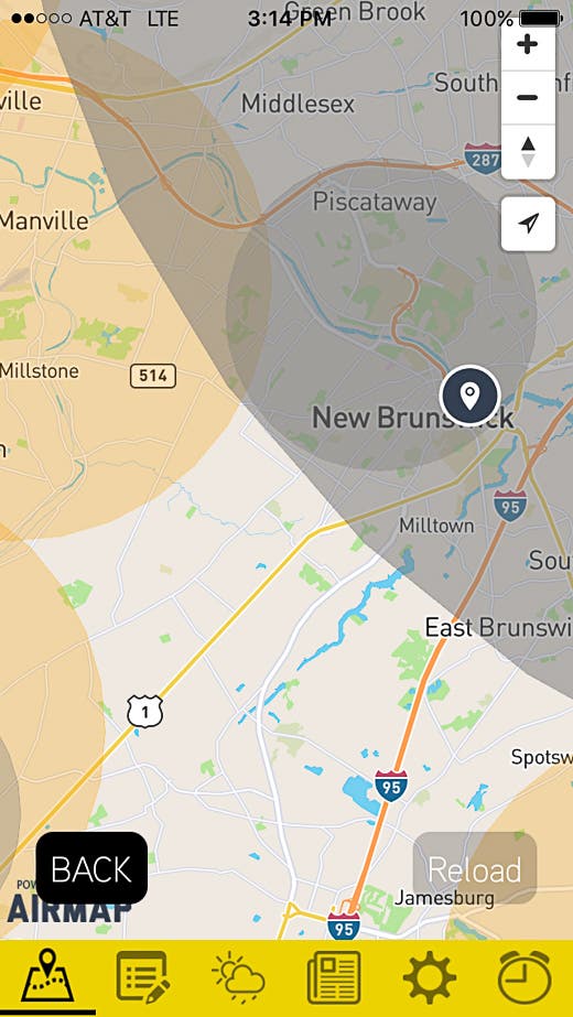
- Airmap:
- Overview: Airmap is widely considered one of the most comprehensive drone management apps available. It offers real-time information on airspace regulations, traffic, and geofencing.
- Features:
- Interactive map that displays no-fly zones and areas of restricted airspace.
- Flight planning tools that allow you to create routes while considering airspace restrictions.
- Notifications for TFRs and temporary changes in airspace rules.
- Personal Anecdote: I remember using Airmap for a weekend trip to the mountains. The app helped me navigate around a temporary flight restriction due to a nearby fire department holding an event. Without it, I might have ended up in a restricted area without knowing!
- LAANC (Low Altitude Authorization and Notification Capability):
- Overview: This FAA-approved app is specifically designed for drone pilots to request permission to fly in controlled airspace quickly and efficiently.
- Features:
- Real-time UAS flight permission, ensuring you can access controlled airspace legally.
- Detailed mapping of airspace restrictions, active TFRs, and weather conditions.
- Compatibility with various other drone apps for an enhanced flying experience.
- Use Case: If you’re an adventurous pilot looking to take stunning city shots, LAANC allows you to request airspace access before your flight, ensuring compliance with local regulations.
- Drone Buddy:
- Overview: Designed for recreational and commercial drone pilots, this app offers a clear and clean interface outlining local airspace classifications.
- Features:
- Markers indicating where you can and cannot fly, based on your GPS location.
- A simple checklist for drone operators, which is helpful for pre-flight preparations.
- Personal Story: On one particular day, I decided to take my drone for a spin at a local park. With Drone Buddy’s checklist feature, I ensured I had all my settings correct before hitting the skies, keeping my nerves at bay! 🛩️
- Skyward:
- Overview: A user-friendly application designed for both recreational and commercial UAV pilots, Skyward offers detailed maps of airspace and flight advisories.
- Features:
- An airspace map that highlights specific rules for each airspace class.
- Flight logging capabilities to help track flying activities and compliance.
- Integrations with FAA services for seamless authority notifications.
- Use Case: If you’re a commercial drone operator, Skyward’s flight logging feature can prove invaluable for legal compliance and business analytics.
- UAV Forecast:
- Overview: While primarily a weather app, UAV Forecast also provides critical information about local airspace restrictions.
- Features:
- Real-time weather updates including wind speed, temperature, and cloud cover which are essential for safe flying.
- Airspace indicators showing zones for safe flying and meteorological conditions.
- Pro Tip: Use both UAV Forecast and one of the mapping tools mentioned above in conjunction to ensure that you have a clear picture of weather and airspace conditions before you fly.
Features of Drone Map Services
While the apps mentioned are fantastic tools, let’s dive deeper into the features that make these drone map services invaluable to every pilot. You wouldn’t want a GPS system that just gives you directions without showing you road conditions or traffic! Likewise, effective drone mapping services should encompass a variety of essential features:
- Geofencing:
- Many mapping tools integrate geofencing to prevent drones from entering prohibited areas automatically. This is a crucial feature to avoid unintentional violations.
- Benefits include reducing the risk of fines or danger in crowded areas by working with your drone’s built-in capabilities.
- Real-Time Updates:
- Airspace regulations and temporary flight restrictions change frequently. Ensure your mapping tool provides real-time updates to stay informed.
- Apps like Airmap and LAANC excel in this category, continuously fetching the latest information from the FAA and local authorities.
- Flight Planning and Routing:
- Effective flight planning tools ensure you can chart your route while considering airspace restrictions, weather conditions, and personal preferences.
- Applications should allow for waypoint creation and resume flight plans for multi-waypoint missions.
- Integration with Other Apps:
- The best mapping services work well in concert with other drone applications like weather services and logging tools.
- By combining features from various apps, you can maximize your flying efficiency and safety.
- User-Friendly Interface:
- A clear and intuitive interface makes it much easier to access crucial information without sifting through technical jargon.
- Many popular tools offer engaging and visually appealing interfaces, making them enjoyable to use.
- Educational Resources:
- A host of mapping services provides educational content to help drone pilots improve their skills and learn about regulations. This can include tutorials, feature explainers, and best practice guides.
In summary, equipping yourself with the best fly zone mapping tools enhances your drone flying experience and keeps you compliant with safety regulations. My journey into the world of drones has been significantly smoother thanks to these amazing apps, and I can confidently say they’ve made me a safer and more knowledgeable pilot. So, before your next flight, dive into these mapping tools and elevate your flying experience! 🌤️📱✨
Safety Tips for Flying in Different Zones
Having explored the world of fly zone mapping tools and apps, it’s now crucial to discuss how to actually stay safe while flying your drone, especially in different zones. Airspace can vary significantly from open fields to bustling urban environments, and knowing how to adapt your flying techniques is key to a positive and safe experience. Let’s dive into some essential safety tips, starting with the precautions needed in high-traffic areas.
High-Traffic Areas Precautions
Flying in high-traffic areas can be exciting, as you get to capture dynamic cityscapes or crowded events. However, it also comes with unique risks. Here’s how to navigate these environments safely:
- Stay Aware of Your Surroundings:
- Always maintain a visual line of sight with your drone. This ensures that you can quickly respond to any unexpected obstacles or other flying objects.
- Keep an eye on people, vehicles, and other drones. I recall one time when I was taking shots of a local festival; I had to dodge another drone that unexpectedly entered my flight path!
- Flight Altitude:
- When flying in congested areas, adhere to the FAA’s altitude regulations. While the general rule is to stay below 400 feet, it’s a good idea to stay lower in crowded spaces to avoid colliding with other airborne crafts.
- Choose to fly at a height where you can easily identify obstacles, especially tall buildings and trees.
- Use Geofencing Features:
- Many modern drones come equipped with geofencing features that keep them out of restricted areas. Ensure that this feature is activated before takeoff, especially in urban settings where regulations can be strict.
- Stay informed about current no-fly zones in your area by utilizing mapping tools discussed earlier.
- Plan Your Takeoff and Landing:
- Always select a safe takeoff and landing area. Ensure the location is free of crowds and potential obstructions.
- For example, when shooting a drone video at a local marathon, I made sure to take off from a quiet corner away from the runners, ensuring I would not disrupt the event.
- Announce Your Presence:
- If you’re flying in an area with many people, consider using verbal announcements or visual signals to inform bystanders about your drone. This can help prevent accidents and confusion.
- I’ve previously used a small pop-up banner stating “DRONE IN OPERATION” just to keep everyone informed.
- Avoid Flying During Busy Events:
- If possible, try to avoid flying during large public gatherings like concerts or sporting events, unless you have obtained permission from the event organizers. These events come with their own set of challenges, including crowded spaces and increased liability.
- For instance, I usually opt for late-afternoon park visits instead of busy mornings when families are present.
- Emergency Protocols:
- Always have a plan for emergencies. Know how to execute a “Return to Home” function on your drone if it becomes unresponsive.
- Test your fail-safes periodically to understand how they will perform under different conditions.
In summary, high-traffic areas pose unique challenges, but with attention to detail, the right preparation, and smart flying strategies, you can safely navigate these environments and capture stunning footage. 🌆🚁
Regional Weather Impact on Drone Flying
Moving on from urban settings, let’s discuss another crucial factor that can greatly impact your flying experience: weather. Weather plays an essential role in making informed flying decisions, as certain conditions can limit your ability to pilot safely. Here are some tips to consider regarding regional weather:
- Wind Conditions:
- Wind can affect your drone’s flight stability. Be particularly cautious of flying in gusty conditions, which can make your drone harder to control.
- As a rule of thumb, if wind speeds exceed 15 miles per hour, it’s time to reconsider your flight plans, especially for smaller drones. I remember a windy day at the beach, and my drone was struggling against the gusts. I decided to pack it up, and it was a smart move!
- Precipitation:
- Avoid flying during rain or snow. Most drones cannot handle these conditions well, and moisture can damage the electronics, leading to costly repairs.
- It’s always wise to consult weather apps or local forecasts before heading out to ensure optimal flying conditions.
- Temperature Variations:
- Extreme temperatures can impact battery performance. Cold weather can lead to reduced battery life, while extreme heat can affect motor efficiency.
- I’ve had my drone give me low battery warnings much sooner than expected when flying on a cold winter day. Always check your battery levels frequently, especially during prolonged flights in unusual temperatures.
- Visibility Levels:
- Clear visibility is essential for flying safely. Fog, mist, or heavy cloud cover can obscure your view and complicate navigation.
- Whenever you notice reduced visibility, it’s usually best to postpone your flight. For example, I planned a sunrise shoot one morning, but the fog rolled in thick. I opted to wait, which ultimately resulted in clearer skies later in the day!
- Local Weather Patterns:
- Familiarize yourself with your area’s typical weather patterns. Certain regions may have unpredictable storms, sudden gusts, or other weather events that are best to avoid.
- Using historical weather data can be a helpful resource to know when to fly in your local environment.
- Weather Alerts:
- Stay informed about real-time weather alerts and notifications. The last thing you want is to be caught unprepared while flying. Use apps or services that provide weather alerts in your area.
- Many mapping tools will also provide integration with weather data, giving you up-to-the-minute conditions.
In conclusion, your drone flying experience can be significantly impacted by weather conditions. By keeping a close eye on local forecasts and understanding how different weather patterns affect your aircraft, you’ll be able to fly safely and successfully capture stunning aerial shots. Combining these weather-related insights with the previously mentioned high-traffic precautions creates a well-rounded approach to drone safety. By fostering both awareness and adaptability while flying, you can enhance your experience and make every flight enjoyable! 🌦️✈️
Tips for Flying in No-Fly Zones
Having explored the importance of flying safely in various areas, including high-traffic zones and adapting to changing weather conditions, it’s now time to discuss a topic that is crucial for every drone pilot: no-fly zones. Understanding and adhering to these areas is essential for responsible drone operation. Let’s dive into the specifics of no-drone zones, starting with what they are and why they matter.
Understanding No-Drone Zones
No-drone zones are specific areas where drone flights are prohibited or restricted. These zones have been established for safety, security, and privacy reasons. Recognizing these zones isn’t just a matter of being careful; it’s about adhering to laws that are in place to protect both your flying experience and the safety of the general public. Here are some common types of no-drone zones you might encounter:
- Airports:
- Typically, you’ll find a five-mile radius around most airports designated as no-fly zones. This restriction is crucial to avoid interference with manned aircraft operations.
- Positive Anecdote: Once, I planned to fly my drone near a picturesque lake, but upon checking, I discovered an airport nearby. Thanks to the warning from my mapping app, I redirected my flight plans to a safer location.
- Military Installations:
- Military bases represent a significant security concern. Tread lightly here; even coming too close can have serious repercussions.
- Restricted zones can extend several miles beyond base perimeters, depending on the installation’s security requirements.
- National Parks and Wildlife Reserves:
- Many parks prohibit drone flights outright to preserve tranquility for wildlife and visitors. Even if the area seems remote, always double-check regulations.
- I learned this firsthand on a camping trip to a national park. My excitement to capture wildlife with my drone was dashed when I found out about the flying restrictions. It reinforced how vital it is to know about no-fly areas!
- Special Events:
- Large public gatherings, such as concerts, sports events, or rallies, often trigger temporary no-fly zones. Event organizers frequently request these restrictions to ensure public safety.
- Always check local announcements before venturing out, as these zones may change daily or weekly.
- Urban Areas:
- Many cities impose strict regulations on drone flying. Some metropolitan areas have designated zones where drone flights are completely banned, often in highly populated areas.
- This makes it essential to evaluate each flight location carefully. Since many abundant opportunities for stunning shots exist in urban areas, staying compliant is crucial!
To ensure that you remain informed, familiarize yourself with the current regulations at your flying location. Utilizing fly zone mapping apps can help you quickly locate no-fly zones and avoid potential headaches down the line.
Legal Consequences of Violating No-Fly Zones
Now that you understand what no-drone zones are, let’s chat about the legal implications of disregarding these restrictions. Flying in these zones can have serious consequences that you should consider before launching your drone.
- Fines and Penalties:
- The FAA is pretty serious about enforcing no-fly zones. If caught, you could face substantial fines, sometimes upwards of several thousand dollars.
- For instance, a friend of mine decided to take some aerial shots right next to an airport, thinking he could get away with it. He was issued a hefty fine that turned a fun day into an expensive lesson.
- Drone Confiscation:
- In addition to monetary fines, law enforcement can confiscate your drone if you’re found flying in a no-fly zone.
- Imagine investing in a high-quality drone only to see it taken away because of a single oversight!
- Civil Liabilities:
- If your drone causes an accident or damages property while flying in restricted areas, legal liabilities can fall on you. This includes damage to people, private properties, or public domains.
- Aviation liability insurance can provide some peace of mind, but being aware of where you’re flying is paramount in the first place.
- Criminal Charges:
- In severe cases, flying in a designated no-fly zone could result in criminal charges, especially if the flight endangers public safety or national security.
- This can lead to a permanent record, impacting future job prospects or travel, particularly if international drones laws come into play.
- Impact on Community Relations:
- Violating no-fly zones can also harm the reputation of drone pilots within your local community. If word gets around that people are recklessly operating drones, there may be stricter regulations imposed that affect everyone.
- When I first started flying, I made it a priority not only to follow the rules but to foster a positive community image. Any bad press can impact our hobby for years to come.
Overall, the consequences of violating no-fly zones can be severe and long-lasting. By understanding the regulations and committing to safe flying practices, you’ll contribute positively to the drone community and maintain an enjoyable flying experience. In conclusion, knowledge and awareness are your greatest assets as a drone pilot. By understanding what no-fly zones are and recognizing the legal ramifications of flying in those areas, you’ll keep yourself safe and compliant while protecting your investment in your drone. Remember, every responsible pilot adds to the community’s respect and appreciation for our beloved hobby. Fly smart, fly safe! 🛡️🌍✨