
Introduction
The Rise of Drone Technology
Over the past decade, drone technology has surged to the forefront, transforming various industries like never before. What started as a hobbyist’s gadget quickly evolved into a powerful tool for professionals across sectors such as agriculture, construction, real estate, environmental monitoring, and even disaster response. The versatility and accessibility of drones have enabled us to explore new dimensions in how we gather data and visualize the world around us. It’s fascinating to think about how quickly these flying machines have integrated into our daily lives. In the early days of drone technology, you might have seen enthusiasts capturing stunning aerial footage of landscapes or lively events. Fast forward to today, and these drones are equipped with sophisticated sensors and cameras capable of performing highly specialized tasks. For instance, a farmer can now use a drone to assess crop health in real-time, making adjustments more efficiently than ever before. The evolution of drones has not only made them more user-friendly but has also contributed to the sharp decline in costs, allowing more businesses and individuals to invest in drone technology. Made accessible to both amateurs and experts alike, this leap in innovation is a testament to how technology can uplift industries and create new opportunities.
Benefits of Aerial Views
One of the primary advantages of drone technology is the stunning aerial views it provides. From bird’s-eye perspectives, drones deliver a wealth of information that was previously hard to attain without significant time and expense. Here are some notable benefits of using drones for aerial views:
- Enhanced Data Collection: Drones can swiftly cover large areas and capture comprehensive data. Be it a sprawling agricultural field or a busy construction site, aerial views provide an overview that ground-level images simply cannot.
- Improved Decision-Making: Having access to high-resolution images helps in making informed decisions. For example, in agriculture, a farmer can use the data collected by the drone to identify areas that need more water or those that may be suffering from pests.
- Cost-Effective: When compared to traditional methods of data collection, such as manned aircraft, drones are much cheaper. This cost-effectiveness enables even small businesses to utilize aerial data to enhance their operations.
- Accessibility to Hard-to-Reach Areas: Drones can reach locations that might be dangerous or physically difficult for humans. Think about surveying rugged terrains, dense forests, or disaster-struck areas—drones can navigate where others can’t.
To paint a clearer picture, let’s delve into a personal anecdote. Imagine a local farmer named Joe. Last year, Joe decided to invest in a drone equipped with multispectral imaging capabilities. After a few weeks of usage, he found that his yields increased significantly. By quickly assessing crop health from above, he could pinpoint issues before they became widespread, ensuring that every part of his field thrived. The applications of drones extend far beyond agriculture. Businesses in construction can conduct site surveys rapidly, helping project managers visualize the progress without needing to be physically present. Real estate agents can offer virtual tours, providing potential buyers with a stunning overview of properties from different angles and at various times of day. Moreover, drones provide critical assistance in environmental monitoring and disaster relief. They can help track wildlife or survey ecosystems while ensuring minimal disturbance to habitats. In summary, the rise of drone technology has revolutionized our ability to view and analyze the world. Aerial views provided by drones empower various industries, from farming to real estate, creating efficient systems that enhance productivity while offering unprecedented insights. As we continue to explore the vast potentials of drones, it’s exciting to think about the innovative applications just waiting to be discovered. 🚀

Drone Mapping in Agriculture
Precision Farming Techniques
As you dive deeper into the world of drone technology, agriculture appears as one of its most impactful beneficiaries. Precision farming techniques have dramatically evolved through the integration of drone mapping. But what exactly does this mean? Simply put, it’s about using data and analytics to make informed decisions for optimizing farming practices. Drones play a pivotal role in gathering data quickly and efficiently, allowing farmers to pinpoint areas needing attention, all from a bird’s-eye view. Imagine you’re a farmer like Sarah, who runs a small vineyard. Before adopting drone technology, assessing her crop health meant walking through rows of her vines, which was painstaking and often ineffective. After trying out drone mapping, she discovered a whole new world in managing her vineyard. Now Sarah can analyze her entire field in a matter of minutes! Here are some ways precision farming techniques benefit farmers:
- Data Collection: Drones gather large quantities of data at a higher frequency than traditional methods. This data can include detailed images, environmental factors, and soil conditions, enabling farmers to make decisions based on concrete evidence rather than guesswork.
- Real-Time Analysis: With advanced sensors, drones can conduct real-time analysis of the crops. Often, this includes multispectral or thermal data to assess plant health, moisture levels, and nutrient content.
- Resource Optimization: Precision farming minimizes waste by applying resources—like water, fertilizers, and pesticides—more effectively. For instance, instead of spraying pesticides over an entire field, drones allow farmers to treat only the affected areas, saving money and reducing chemical use.
- Yield Prediction: Accurately analyzing crop data helps farmers estimate their yields better. Understanding crop health at scale allows for better planning ahead of harvest, optimizing sales strategies.
Monitoring Crop Health
Monitoring crop health is perhaps one of the most critical applications of drone mapping in agriculture. With the power of aerial imagery, farmers can track the health of their crops consistently, leading to better management and improved yields. Taking the case of Sarah’s vineyard one step further, she began using drones equipped with multispectral cameras to monitor plant health across her entire field. The drones were able to detect variations in vegetation that are not easily visible to the naked eye. Sarah received detailed heat maps highlighting areas that were thriving, as well as those in need of attention. Here’s how drone mapping plays a crucial role in monitoring crop health:
- NDVI Analysis: Drones can utilize a technique called Normalized Difference Vegetation Index (NDVI), which analyzes the light reflected by plants to determine their health. This index helps in identifying stressed plants or areas in the field that require immediate attention.
- Early Detection of Pests and Diseases: With timely drone data, farmers can detect signs of pests or diseases early on. Being proactive, rather than reactive, in treatment can save acres of crops from potential loss.
- Irrigation Assessment: Drones can identify variations in soil moisture. If some areas are drier than others, irrigation can be adjusted accordingly. This maximizes the effectiveness of water usage, especially in times of drought.
- Field Mapping and Inventory: Drones can create highly detailed maps that aid in planning for crop rotations and overall management strategies. This allows farmers to see which crops are performing best in different sections of their fields.
In conclusion, drone mapping is revolutionizing agriculture through precision farming techniques and meticulous crop health monitoring. By harnessing aerial data, farmers like Sarah are empowered to make informed decisions that lead to enhanced productivity, resource efficiency, and ultimately, increased profit. The technology’s potential is just beginning to be explored, and as more farmers adopt these innovative practices, we can expect a significant shift toward a more sustainable and productive agricultural landscape. 🌾

Drone Mapping in Construction
Site Surveying and Planning
Transitioning from agriculture to construction, drone mapping serves as a game-changer in how professionals survey and plan construction sites. In an industry where precision and efficiency are paramount, drones provide a unique advantage that impacts timelines, costs, and overall project success. Consider John, a project manager overseeing a commercial building project. Before utilizing drone mapping, John relied on traditional surveying methods that often took days to gather all necessary data. With the introduction of drones, site surveying became a breeze. Using drones equipped with high-resolution cameras and LiDAR technology, he was able to gather data much faster and create detailed topographic maps in just hours. Here are some key benefits of drone mapping in site surveying and planning:
- Time Efficiency: Drones can cover vast areas quickly, which means data can be collected in a fraction of the time compared to traditional methods. This allows for rapid decision-making right from the start.
- Cost-Effectiveness: By reducing the time spent on surveying, drones ultimately lower labor costs. Additionally, the advanced technology can decrease the need for heavy machinery, further reducing expenses.
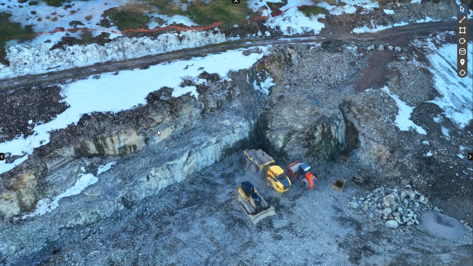
- Accuracy: Drones create highly accurate 3D models and surface contour maps. These detailed visuals reduce errors in planning and enhance the overall quality of the project.
- Easy Access to Hard-to-Reach Areas: Drones can survey sites that may be unsafe or inaccessible for humans, like cliff sides or dense urban sites, providing a comprehensive view without risking lives.
John experienced firsthand how these advantages translated into saved time and cost efficiency. The project was completed ahead of schedule, and stakeholders could visualize the project through stunning aerial images, leading to more informed discussions and decisions.
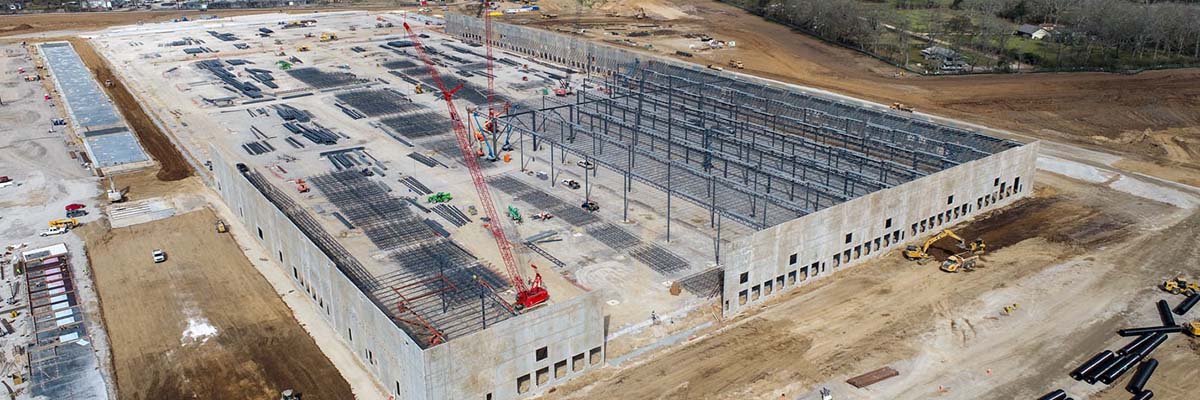
Progress Tracking and Inspections
Once the construction phase begins, drone mapping continues to play an indispensable role in tracking progress and conducting inspections. The ability to easily capture aerial footage allows project managers like John to maintain a real-time pulse on the site, ensuring everything remains on track. The benefits of utilizing drones for progress tracking and inspections include:
- Routine Documentation: Drones can be deployed regularly to capture high-resolution images of the site, allowing for easy comparison against original plans. This routine documentation provides insights into whether the project is on schedule or if adjustments are needed.
- Enhanced Communication: Aerial visuals make it easy to communicate progress with stakeholders, clients, or investors. Instead of relying on lengthy reports, a short presentation showcasing drone footage can effectively illustrate current status and future plans.
- Identifying Issues Early: Regular drone flights make it simpler to spot any potential problems early on. For example, if materials arrive incorrectly or if there’s an unexpected deviation from the design, the drone footage can help identify these issues quickly, allowing for prompt resolution.
- Safety Inspections: Drones can assess the safety and compliance of the job site. They can monitor worker safety, check equipment locations, and even assess the risk of hazardous materials, ensuring that all safety protocols are being followed with minimal disruption to workflow.
In sharing John’s experience again, one incident stands out: During a routine inspection using the drone, John noticed discrepancies in a section of the framing that had gone up. Although it seemed like an isolated issue at first glance, upon closer inspection with the drone’s footage, it became clear that it was a widespread problem. By addressing it promptly, John saved the company from potential delays and significant rework later down the line. In summary, drone mapping in construction harnesses the transformative power of aerial technology. From the initial site surveying and planning stages to ongoing progress tracking and inspections, drones streamline workflows, enhance accuracy, and provide a level of insight that revolutionizes how construction projects unfold. Embracing this technology not only optimizes processes but also propels the industry toward a more efficient and effective future. 🏗️

Drone Mapping in Real Estate
Virtual Property Tours
Shifting our focus to the realm of real estate, drone mapping has become an invaluable tool for agents and home sellers alike. In today’s competitive market, the way properties are showcased can significantly impact buyer decisions. Enter drones, which have revolutionized the concept of virtual property tours, providing potential buyers with a unique perspective that traditional photography simply can’t match. Imagine you’re a real estate agent named Emma, who’s eager to sell a stunning waterfront property. Instead of relying solely on standard photos taken from ground level, you decide to incorporate drone footage into your listings. This decision pays off significantly. With drones, you can capture breathtaking aerial views of both the property and its surroundings—showing not just the house but also the beautiful landscape, nearby amenities, and even traffic patterns leading to the beach. Here are a few reasons why virtual property tours using drones are becoming essential in real estate:
- Immersive Experience: Aerial footage provides a 360-degree view that allows potential buyers to visualize the layout and size of the property better. This immersive experience engages buyers and provides context that traditional photos can’t deliver.
- Highlighting Neighborhood Features: Drones help to showcase not just the property but also the neighborhood. Whether it’s local parks, schools, or proximity to shopping centers, high-quality aerial shots can reveal what makes the area appealing.
- Saves Time for Buyers: Virtual tours allow interested buyers to assess properties that pique their interest without needing to schedule countless in-person visits. Drones make it easy for them to narrow down their choices, ultimately saving time for both parties.
- Enhanced Online Listings: In a digital age where online presence is paramount, including drone footage in listings improves visibility. Drones can capture stunning images that stand out on multiple platforms and draw more attention to the property.
Emma found that many prospective buyers reached out after seeing her listings featuring drone footage. They felt a deeper connection to the properties, which made their search more efficient.
Assessing Property Features
In addition to showcasing properties through exciting virtual tours, drone mapping is also instrumental in assessing property features. For buyers and developers, understanding a property’s attributes is crucial for informed decision-making. Drones enable this in a way that traditional methods simply can’t compete with. Take the example of the Jones family, who are considering purchasing a large plot of land for development. They’re interested in the terrain, topography, and existing features, such as trees and bodies of water, before making their investment. By utilizing a drone, they gain comprehensive insights into the entire property with minimal effort. Here’s how drone mapping can help in assessing property features:
- Topographic Mapping: Drones equipped with advanced sensors create accurate topographic maps, which can help buyers visualize property dimensions, slopes, and elevations. This is vital for developers looking to plan their construction effectively.
- 3D Modeling: In addition to 2D visuals, drones can create detailed 3D models of properties. This helps buyers better understand spatial relationships and layouts before any ground work even begins.
- Identifying Land Use: Aerial imagery helps to differentiate various land uses and assess how neighboring properties may impact potential developments. Buyers can spot boundaries and understand zoning laws more clearly.
- Environmental Assessments: Drones can be used to support environmental assessments, checking for features like wetlands or assessing vegetation types. This information can influence both development plans and potential costs.
Returning to the Jones family, they were able to make a confident decision about purchasing the land that fit their aspirations and budget thanks to the drone’s insights. Without the need for extensive ground surveys, they felt empowered to move forward with their plans, knowing they had a complete understanding of the property. In summary, drone mapping in real estate enriches the buying experience significantly. From captivating virtual property tours to detailed assessments of property features, drones provide unique insights that not only help buyers make informed decisions but also empower agents to showcase their listings more effectively. As this technology continues to evolve, the potential to shape the real estate landscape will only grow, driving innovative practices and approaches in an ever-competitive market. 🏡✨
Drone Mapping in Environmental Conservation
Wildlife Monitoring and Protection
As we transition into the critical realm of environmental conservation, drone mapping has emerged as a powerful ally in the quest to monitor and protect wildlife. With their ability to cover vast areas quickly and capture high-resolution images, drones offer conservationists innovative tools to track animal populations and their habitats, ultimately helping to inform protective measures. Imagine a conservation officer named Mia, working tirelessly to protect endangered species in a national park. Before drones became available, monitoring wildlife behavior and populations required considerable manpower and often went without the necessary insights. With the introduction of drone mapping, Mia’s job transformed dramatically. Drones equipped with thermal imaging cameras allow Mia to observe animal movement patterns without disturbing their natural habitats. For example, during a recent mission, she used a drone to scan a dense forest area where a rare bird species nested. The drone was able to access hard-to-reach places and provided invaluable data on nesting locations, which helped to develop effective conservation strategies. Here are several ways drones are enhancing wildlife monitoring and protection:
- Habitat Mapping: Drones can create detailed habitat maps, allowing conservationists to identify critical habitats for endangered species. This information helps prioritize areas for protection and management.
- Population Tracking: By regularly flying drones over an area, conservationists can track the movements and population dynamics of various species. This data is crucial for assessing the health of vulnerable populations.
- Behavioral Studies: The non-invasive nature of drone surveillance allows scientists to study animal behavior without interference. This data can reveal how animals interact with their environment and each other, providing deeper insights into their ecosystems.
- Anti-Poaching Efforts: Drones are increasingly used for anti-poaching surveillance. Equipped with real-time video feeds and thermal imaging, they are integral in patrolling large reserves, helping detect and deter illegal activities.
Mia found that her use of drones not only enhanced productivity but also fostered better collaboration with local communities. Engaging them in conservation efforts empowered them to become stewards of their surroundings, thus ensuring a more sustainable approach to protecting wildlife.
Ecosystem Mapping and Analysis
As we further explore drone mapping in environmental conservation, we must also highlight its role in ecosystem mapping and analysis. Understanding ecosystems, their functions, and interdependencies is vital for fostering effective conservation strategies. Drones provide a valuable lens to analyze these intricate systems, giving researchers a comprehensive understanding of ecological dynamics. Consider the efforts of Ben, an ecologist studying a delicate wetland ecosystem. Ground-based surveys often proved challenging and time-consuming when mapping the complex interactions within wetland environments. When Ben began using drones, he quickly realized their potential to revolutionize his research. Here’s how drone technology aids in ecosystem mapping and analysis:
- High-Resolution Imagery: Drones can capture detailed aerial images that help identify vegetation types, water sources, and land use patterns. This information is essential for understanding the health of different ecosystems.
- Change Detection: By conducting regular drone surveys, researchers can monitor changes in ecosystems over time, from habitat loss to the impacts of climate change. These insights are crucial for timely intervention.
- Biodiversity Assessment: Drone mapping can aid in assessing biodiversity by identifying various species present within an ecosystem. This data helps researchers understand the resilience of ecosystems and plan for conservation initiatives.
- Water Quality Monitoring: Drones can also gather data on water bodies, detecting algal blooms or pollution sources. Monitoring water quality is essential for protecting aquatic ecosystems and ensuring safe habitats for wildlife.
In Ben’s work, the combination of aerial data and his expertise led to significant insights about biodiversity in the wetland. By uncovering the intricate relationships between plant species, wildlife, and hydrology, he was able to recommend targeted conservation actions to prevent further degradation. In summary, drone mapping plays a crucial role in environmental conservation, particularly in wildlife monitoring and ecosystem analysis. From enhancing the protection of endangered species to providing insights into complex ecosystems, drones empower researchers and conservationists to take informed actions protecting our planet’s delicate environments. As this technology continues to evolve, we can look forward to a future where conservation efforts are enhanced and informed by the rich data drones provide, ultimately striving toward a more sustainable world. 🌿🐾

Drone Mapping in Disaster Response
Rapid Damage Assessment
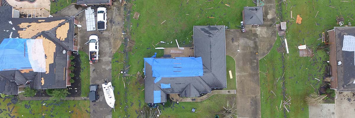
As we pivot into the critical realm of disaster response, drone mapping emerges as an indispensable tool for quickly assessing damage in the aftermath of natural calamities. When disaster strikes—be it due to hurricanes, earthquakes, floods, or wildfires—the ability to gather accurate information swiftly is vital for effectively deploying resources and coordinating relief efforts. Consider Ryan, an emergency responder who found himself in the field after a devastating earthquake struck a coastal town. Traditional methods of damage assessment often required extensive manpower and time, delaying urgent relief initiatives. However, with drones in his toolkit, Ryan could survey the disaster area from above, providing real-time data to his team within moments. Drones equipped with high-resolution cameras and thermal imaging technology allow for rapid damage assessment, and here’s how they aid responders like Ryan:
- Quick Aerial Surveys: Drones can cover large areas in a fraction of the time it would take ground teams, enabling responders to create an overview of the situation almost instantly. This efficiency can save lives by speeding up the deployment of resources.
- Real-Time Visualization: By providing real-time feed to command centers, drones allow decision-makers to visualize the extent of damage and prioritize response efforts effectively. No longer do responders need to rely solely on verbal reports; they can see the situation for themselves.
- Identifying Hazards: In a disaster scenario, the environment is often unstable. Drones can assess hazardous areas, such as collapsed buildings or landslide-prone zones, pinpointing where it is safe to send ground teams.
- Mapping Infrastructure Damage: By creating detailed maps of the affected areas, drones help in assessing critical infrastructures (roads, bridges, utility lines). This allows authorities to prioritize repairs, ensuring vital services are restored as quickly as possible.
Ryan experienced the transformation firsthand during the earthquake response. The data collected through drones not only allowed them to assess damage more efficiently but also provided a clear visual representation that could be shared with nonprofit organizations and government agencies. This comprehensive approach enabled them to coordinate relief efforts more effectively.
Search and Rescue Operations
Following the immediate need for damage assessment, drone mapping shines in search and rescue operations, where time is of the essence. In situations where victims may be trapped or injured, drones equipped with advanced technology can make a significant difference in saving lives. Imagine a scenario in the aftermath of a severe flood. Local authorities deploy drones to search for missing individuals in hard-to-reach areas, where traditional search methods may fall short. Drones provide the necessary tools to locate stranded individuals by covering vast areas quickly and effectively. Here’s how drones contribute to successful search and rescue operations:
- Thermal Imaging Capabilities: Drones equipped with thermal cameras can detect body heat, making it easier to locate individuals who may be trapped under debris or in densely packed areas, even during the nighttime.
- Wide Coverage Area: Drones can scan areas that might be challenging to reach on foot or by vehicle, such as flood zones or landslide-affected regions. This expanded coverage significantly enhances the chances of finding rescue targets quickly.
- Communication Tools: Many drones are equipped with loudspeakers, allowing rescuers to communicate with individuals who are stranded. This technology can offer reassurance while guides provide instructions for safe evacuation.
- Data Collection for Coordination: As drones gather and transmit data, rescue teams can synchronize their efforts more effectively. This real-time data stream helps authorities allocate resources efficiently based on situational developments.
In search and rescue operations, the power of drone technology can be transformative. With time-sensitive situations at hand, even small delays can have critical consequences. Emergency teams, like the ones Ryan worked with, have found that drones allow them to quickly zero in on where help is most needed. In summary, drone mapping plays a pivotal role in disaster response, particularly in rapid damage assessment and search and rescue operations. By providing real-time data and enabling swift decision-making, drones help responders manage crises more effectively and efficiently. As these technologies continue to advance, their impact on disaster management will only grow, ultimately saving more lives and reducing the devastation caused by disasters. 🌍🚁
Regulatory Challenges in Drone Mapping
Privacy Concerns
As we dive deeper into the fascinating world of drone mapping, it’s crucial to address some of the regulatory challenges that accompany this technology, particularly in terms of privacy. Drones can capture stunning images and gather vast amounts of data, but this capability also raises significant concerns about how this information is used—and how it might infringe on individual privacy rights. Let’s consider the case of Lisa, a residential homeowner who suddenly found herself in the spotlight. One morning, she noticed a drone hovering over her backyard, equipped with a camera. While the drone was likely part of a nearby construction project’s mapping efforts, Lisa felt uneasy about the potential for her private moments to be captured without her knowledge. Privacy concerns in drone mapping often center around the following areas:
- Invasion of Personal Space: Drones can easily fly over private properties, capturing images and videos without the owners’ consent. This encroachment raises ethical questions about personal privacy and the right to control one’s own space.
- Data Collection & Usage: With the capacity to collect vast amounts of data, there’s a risk of that data being misused or shared in ways that violate personal rights. For instance, information about individuals’ activities, habits, and interactions could be exploited by third parties if not adequately protected.
- Lack of Clear Regulations: Many regions still lack comprehensive laws governing drone usage, leading to confusion for both drone operators and citizens. This uncertainty can result in unintentional violations of privacy rights.
To strike a balance between utilizing drone technology and preserving privacy, several measures could be implemented, such as:
- Clear Guidelines: Establishing regulations that define the acceptable usage of drones concerning privacy can help protect individuals while enabling industries to benefit from drone mapping.
- Consent Requirements: Implementing requirements for drone operators to obtain consent from property owners before conducting aerial surveys can serve as a foundational step toward defending privacy.
- Public Awareness Initiatives: Increasing awareness about drone technology and its intended uses can empower individuals to understand their rights and the regulatory landscape around drone operations.
For Lisa, the incident with the drone prompted her to seek clarity on local regulations about drone usage. This experience highlighted a need for better communication between drone operators and the public, creating a path toward fostering trust.
Airspace Regulations
Alongside privacy concerns, airspace regulations present another significant hurdle in the adoption of drone mapping technology. As drones gain popularity, managing their integration into congested airspace while ensuring safety remains a vital challenge for regulatory bodies. Take the case of a construction company that recently invested in drones for mapping their job sites. One day, during a routine flight over a bustling city, they received a notification from air traffic control, informing them that the drone was operating in restricted airspace—an unexpected hiccup that set their project back. Airspace regulations for drones generally cover various facets, including:
- Restricted Zones: Many areas, such as near airports, military bases, and emergency response zones, are prohibited for drone flights. Navigating these restrictions is crucial for drone operators to avoid legal ramifications.
- Altitude Restrictions: There are specific altitude limits for drone operations, often capped at around 400 feet. For industries that require detailed aerial mapping, these limitations may hinder their ability to collect the necessary data.
- Authorized Pilots: Many regions require drone operators to obtain licenses or certifications to fly legally. This ensures that operators are educated about regulations and safety procedures.
- Coordination with Air Traffic Control: As airspace becomes increasingly crowded, establishing communication protocols between drone operators and air traffic control is essential for ensuring safe operations.
Drone operators must stay informed about the evolving regulatory landscape in their jurisdictions actively. Companies and individuals can foster safety in airspace through:
- Training and Certification: Investing in proper training helps operators understand airspace restrictions and safe flying practices. This ensures compliance and reduces the risk of accidents or legal issues.
- Use of Technology: There are apps and software tools available that provide real-time information about airspace restrictions, helping operators navigate changing regulations and stay compliant.
Ultimately, the integration of drones into society raises important questions about privacy and airspace safety. The experiences of individuals like Lisa and businesses navigating these challenges highlight the need for comprehensive regulations that consider the benefits of drone technology while protecting personal rights and ensuring safe operations. By addressing these regulatory challenges, we can create a future where drone mapping continues to thrive, delivering invaluable data and insights across industries while respecting privacy and safety concerns. 🚁🌐
Future Trends in Drone Mapping
Advancements in AI and Data Analytics
As we look ahead in the world of drone mapping, one of the most exciting developments on the horizon is the integration of artificial intelligence (AI) and advanced data analytics. These technologies promise not only to enhance the capabilities of drone mapping but also to revolutionize the way industries utilize the data collected by drones. To illustrate the impact, let’s picture Alex, a researcher working in environmental conservation. After adopting drones to monitor wildlife populations, Alex realized the vast amounts of data gathered were overwhelming. This is where AI stepped in, providing sophisticated tools to analyze the data efficiently. Instead of spending hours poring over images and numbers, Alex could use AI algorithms to identify patterns, make predictions, and generate actionable insights. Here are some key advancements in AI and data analytics that are shaping the future of drone mapping:
- Automated Image Recognition: AI-powered algorithms can analyze vast datasets of aerial images to identify specific features, such as crop health or wildlife populations. This automation not only speeds up data processing but also minimizes human error.
- Predictive Analytics: Combining drone data with predictive modeling enables industries to forecast trends based on historical patterns. For example, farmers can use this to anticipate crop yields or assess the risk of pests, allowing them to make informed decisions early on.
- Enhanced Decision-Making: With the ability to analyze data in real time, organizations can respond more quickly to changing conditions. For instance, disaster response teams can assess damage and allocate resources more effectively, leading to faster recovery efforts.
- Data Visualization: The integration of AI provides sophisticated visualization tools that present complex data in easily digestible formats, making it simpler for stakeholders to grasp insights and make informed choices.
After implementing these technologies, Alex’s research projects became far more efficient. The data-driven insights derived from AI not only improved conservation strategies but also allowed Alex to present compelling evidence to policymakers, increasing awareness of environmental issues.
Integration with Internet of Things (IoT) Technologies
Another significant trend shaping the future of drone mapping is the integration of drone technology with the Internet of Things (IoT). As IoT devices continue to proliferate—ranging from smart sensors in agriculture to weather stations—drones will increasingly be used to gather, analyze, and act upon data collected from these interconnected devices. Imagine Sarah, a farmer who has deployed a range of IoT sensors throughout her fields to monitor soil moisture, temperature, and humidity levels. By integrating her drone mapping system with these IoT sensors, Sarah can achieve unprecedented precision in her farming practices. Here’s how the integration of drones with IoT technology is set to transform various industries:
- Real-Time Data Collection: Drones can act as mobile data-gatherers, collecting information from IoT devices and transmitting it to central systems. This real-time data flow enables better decision-making across sectors.
- Smart Agriculture: By combining drone aerial surveys with IoT sensor data, farmers can optimize water usage, track pest infestations, and enhance crop yields. The ecological benefits are immense, leading to more sustainable farming practices.
- Infrastructure Monitoring: Drones paired with IoT sensors can monitor aging infrastructure, such as bridges and roads, providing constant data on their condition and predicting maintenance needs before issues become critical.
- Urban Planning: In smart cities, drones can integrate real-time data from IoT sensors deployed across various sectors, assisting urban planners in managing resources more effectively and improving citizens’ quality of life.
Sarah’s farm operations benefited greatly from this integration. By analyzing data from her IoT sensors alongside drone imagery, she optimized her irrigation schedule, ultimately saving water and improving crop health. In conclusion, the future of drone mapping is brimming with exciting possibilities fueled by advancements in AI, data analytics, and IoT integration. These trends will not only enhance the efficiency and accuracy of drone technologies but also empower industries to leverage real-time data for more informed decision-making. As we continue to embrace these innovations, the potential for improved operations, increased sustainability, and enhanced insights across various sectors will undoubtedly reshape the landscape of drone mapping for years to come. The evolution is just beginning, and it promises to be a thrilling journey. 🚀📊